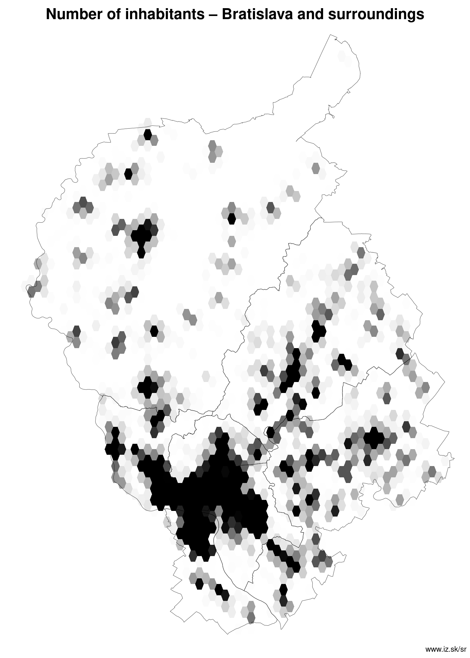
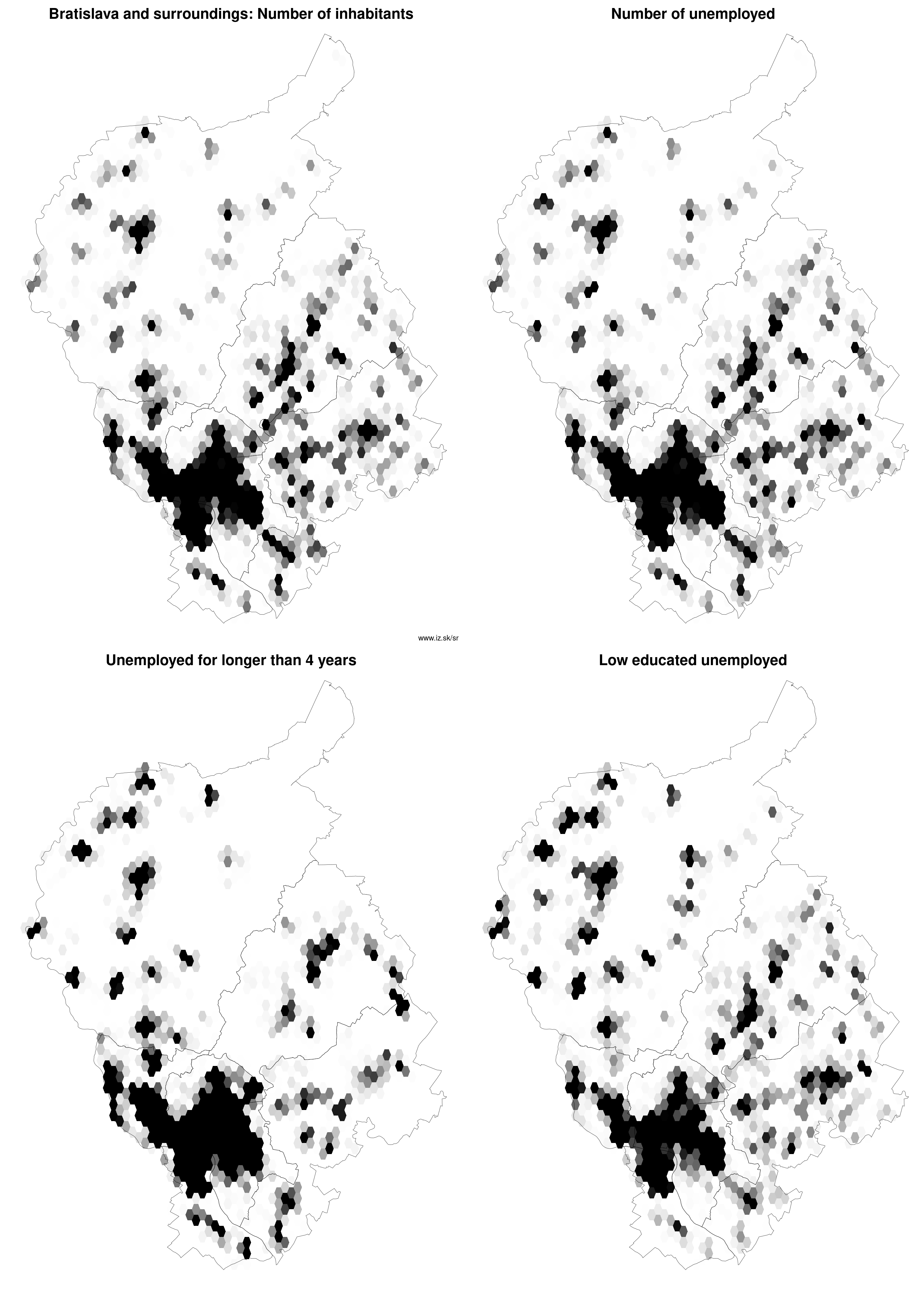
Region Bratislava and surroundings
consists of counties:
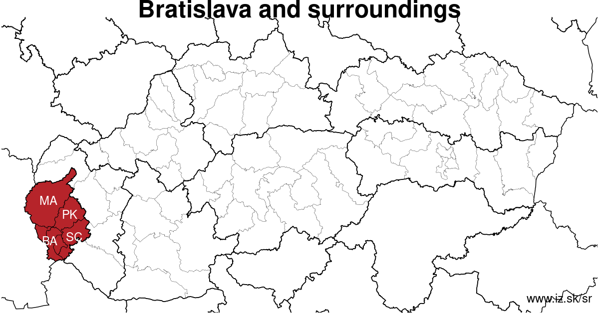
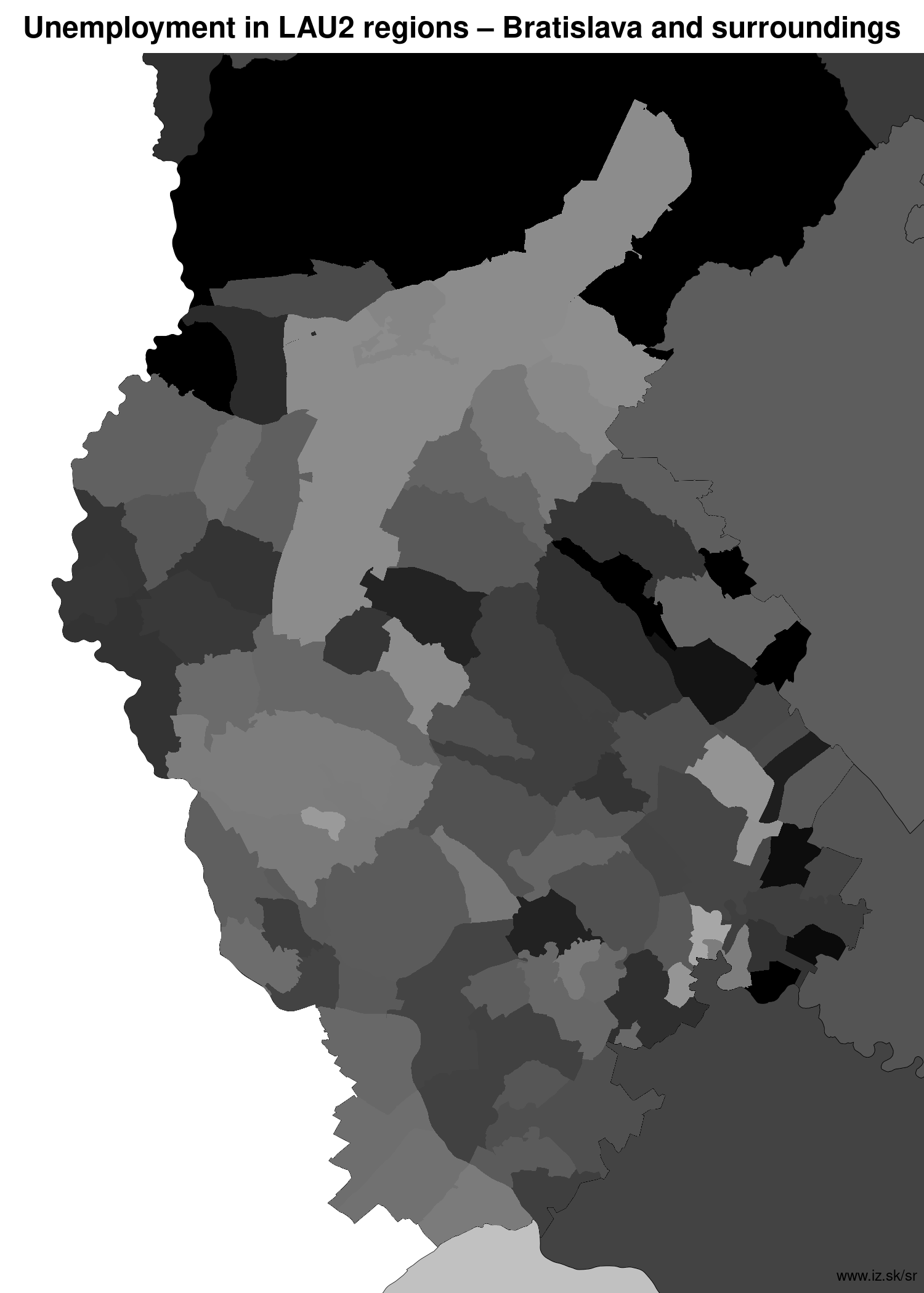
Towns
Region Bratislava and surroundings contains cities Bratislava-Čunovo, Bratislava-Devín, Bratislava-Devínska Nová Ves, Bratislava-Dúbravka, Bratislava-Jarovce, Bratislava-Karlova Ves, Bratislava-Lamač, Bratislava-Nové Mesto, Bratislava-Petržalka, Bratislava-Podunajské Biskupice, Bratislava-Rača, Bratislava-Rusovce, Bratislava-Ružinov, Bratislava-Staré Mesto, Bratislava-Vajnory, Bratislava-Vrakuňa, Bratislava-Záhorská Bystrica, Malacky, Modra, Pezinok, Senec, Stupava, Svätý Jur and 66 villages. More on oma.sk. Statistics on city level on unemployment are for the period of 2024-02-01, for population are fore yar 2021.
name | number of inhabitants in economically active age | number of unemployed number of unemployed women number of long-term unemployed | unemployment rate unemployment rate of women long-term unemployment rate |
|---|---|---|---|
 Bratislava-Petržalka | 113 377 72 950 | 1 718 878 259 | 2.4 % 2.4 % 0.4 % |
 Bratislava-Ružinov | 80 951 52 126 | 1 438 828 340 | 2.8 % 3.1 % 0.7 % |
 Bratislava-Staré Mesto | 46 432 29 368 | 769 408 175 | 2.6 % 2.8 % 0.6 % |
 Bratislava-Nové Mesto | 44 638 28 916 | 729 411 155 | 2.5 % 2.8 % 0.5 % |
 Bratislava-Dúbravka | 36 024 22 639 | 684 371 172 | 3 % 3.3 % 0.8 % |
 Bratislava-Karlova Ves | 35 420 24 398 | 661 360 183 | 2.7 % 2.9 % 0.8 % |
 Bratislava-Rača | 25 964 17 115 | 430 225 97 | 2.5 % 2.7 % 0.6 % |
 Pezinok | 24 838 16 267 | 416 210 86 | 2.6 % 2.5 % 0.5 % |
 Bratislava-Podunajské Biskupice | 23 491 15 313 | 411 214 101 | 2.7 % 2.8 % 0.7 % |
 Bratislava-Vrakuňa | 20 559 14 008 | 359 197 87 | 2.6 % 2.8 % 0.6 % |
 Senec | 20 131 13 394 | 384 216 74 | 2.9 % 3.2 % 0.6 % |
 Malacky | 18 917 12 481 | 302 163 29 | 2.4 % 2.6 % 0.2 % |
 Bratislava-Devínska Nová Ves | 17 117 12 256 | 283 161 59 | 2.3 % 2.6 % 0.5 % |
 Stupava | 12 659 8 068 | 162 97 24 | 2 % 2.3 % 0.3 % |
 Modra | 9 349 6 073 | 194 100 41 | 3.2 % 3.3 % 0.7 % |
 Bratislava-Lamač | 7 761 4 401 | 119 74 30 | 2.7 % 3.3 % 0.7 % |
 Bratislava-Záhorská Bystrica | 6 880 4 363 | 93 60 22 | 2.1 % 2.7 % 0.5 % |
 Bratislava-Vajnory | 6 092 4 016 | 93 49 20 | 2.3 % 2.5 % 0.5 % |
 Svätý Jur | 5 945 3 795 | 93 54 17 | 2.5 % 2.8 % 0.4 % |
 Bratislava-Rusovce | 4 411 2 882 | 68 44 15 | 2.4 % 3 % 0.5 % |
 Bratislava-Jarovce | 2 840 1 767 | 41 23 3 | 2.3 % 2.6 % 0.2 % |
 Bratislava-Devín | 1 952 1 254 | 28 16 9 | 2.2 % 2.5 % 0.7 % |
 Bratislava-Čunovo | 1 668 1 061 | 20 7 3 | 1.9 % 1.4 % 0.3 % |
Villages with over 2000 inhabitants are Bernolákovo (9154), Dunajská Lužná (7839), Chorvátsky Grob (7090), Ivanka pri Dunaji (7078), Slovenský Grob (5515), Rovinka (5445), Šenkvice (5277), Miloslavov (4705), Most pri Bratislave (4094), Malinovo (3968), Veľké Leváre (3730), Rohožník (3594), Zohor (3573), Nová Dedinka (3309), Gajary (3145), Lozorno (3137), Veľký Biel (3013), Závod (2993), Tomášov (2763), Viničné (2733), Hamuliakovo (2679), Plavecký Štvrtok (2548), Budmerice (2510), Častá (2374), Limbach (2346), Kráľová pri Senci (2304), Vysoká pri Morave (2274), Marianka (2272), Zálesie (2243), Láb (2116).
| villages by number of inhabitants | ||||||
|---|---|---|---|---|---|---|
| total | up to 300 | 300 to 500 | 500 to 1000 | 1000 to 1500 | over 1500 | |
| 66 | 2 | 3 | 10 | 11 | 40 | |
Unemployment
| rok | 2012 | 2014 | 2016 | 2018 | 2019 | 2020 | 2021 | 2022 | 2023 |
|---|---|---|---|---|---|---|---|---|---|
| number of unemployed | 19 992 | 21 854 | 17 838 | 11 173 | 11 134 | 15 514 | 17 891 | 13 668 | 12 451 |
| number of long-term unemployed | 5800 | 7771 | 6080 | 2311 | 1877 | 2587 | 5102 | 4038 | 2810 |
| number of people receiving social benefits | 6329 | 5266 | 2805 | 1872 | 1689 | 1761 | 1877 | 4704 | 7195 |
| number of activational workers | |||||||||
| unemployment rate | 4.6 | 5 | 4.1 | 2.6 | 2.5 | 3.5 | 3.8 | 2.9 | 2.6 |
| long-term unemployment rate | 1.3 | 1.8 | 1.4 | 0.5 | 0.4 | 0.6 | 1.1 | 0.9 | 0.6 |
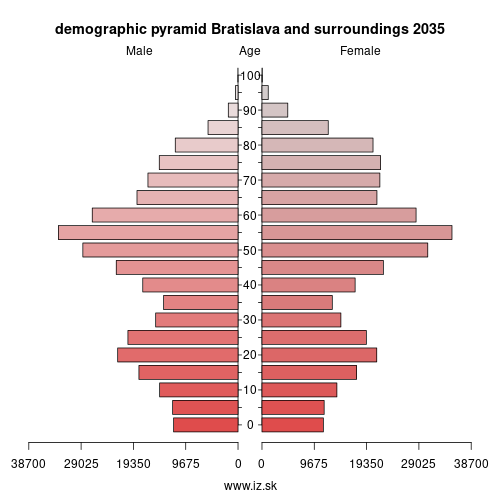
Demographics
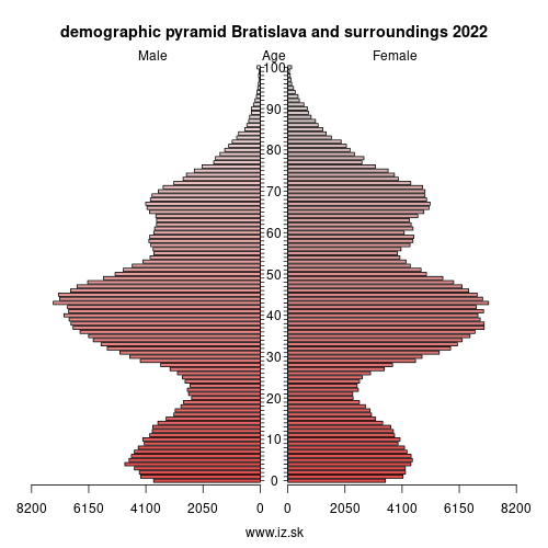
| 2012 | 2014 | 2016 | 2018 | 2019 | 2020 | 2021 | 2022 | 2023 | |
|---|---|---|---|---|---|---|---|---|---|
| number of inhabitants | 612 682 | 625 167 | 641 892 | 659 598 | 669 592 | 677 024 | 723 714 | 728 370 | 728 370 |
| assignation tax | 180 112 118 | 184 809 642 | 228 107 745 | 291 545 842 | 334 977 688 | 350 032 608 | 341 620 714 | 382 569 247 | 453 553 289 |
| demographic dependency | 21.2 | 22.8 | 24.8 | 26.8 | 27.7 | 28.7 | 29.0 | 29.8 | 35.9 |
| number of employed foreigners | 5319 | 6277 | 11 128 | 21 982 | 28 314 | 27 342 | 26 662 | 29 258 | 37 486 |
Number of unemployed
| rok | 2012 | 2014 | 2016 | 2018 | 2019 | 2020 | 2021 | 2022 | 2023 |
|---|---|---|---|---|---|---|---|---|---|
| less than 24 years | 3921 | 3288 | 2091 | 992 | 986 | 1503 | 1579 | 1176 | 1153 |
| 25 to 39 years | 9440 | 8727 | 7226 | 4722 | 4690 | 6467 | 7027 | 5166 | 4760 |
| 40 to 54 years | 6855 | 6499 | 5483 | 3571 | 3635 | 5134 | 6280 | 5037 | 4560 |
| 55 years and more | 3245 | 3340 | 3038 | 1888 | 1822 | 2409 | 3005 | 2289 | 1978 |
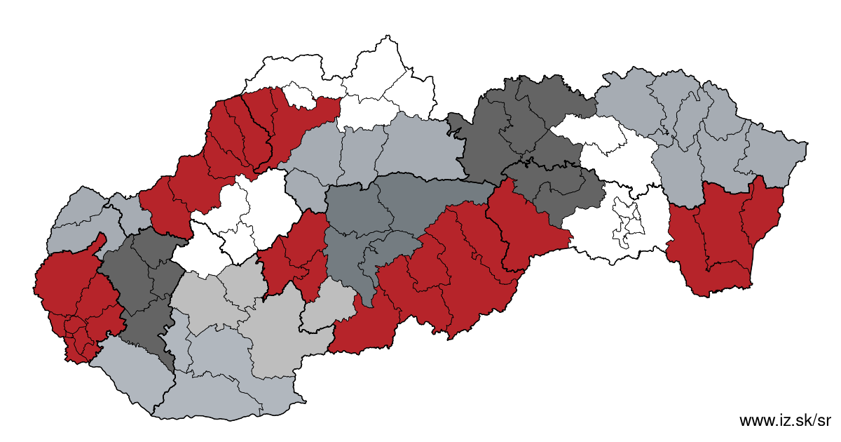
Other regions
- Basic data on Slovak regions
- Labour market indicators of slovak regions.
- Region Bratislava and surroundings
- Region Kopanice
- Region Danube river
- Region lower Vah river
- Region middle Vár river
- Region upper Nitra river
- Region lower Nitra river
- Region Mining cities
- Region Kysuce a Orava
- Region upper Vah river – Liptov
- Region Spiš cities
- Region upper Hron river
- Region Juhoslovenská kotlina
- Region Košice fold and Torysa river
- Region upper Zemplín
- Region lower Zemplín
Suggested citation: Michal Páleník: Regions of Slovakia - Region Bratislava and surroundings, IZ Bratislava, retrieved from: https://www.iz.sk/en/projects/regions-of-slovakia/bratislava
Regions of the Slovak Republic
Due to the need of analysis we have created regions of Slovakia. We will bring more information about these regions from the macroeconomic point of view as well as from the point of view of the labour market.. . .
Similar articles
Banská Bystrica Region, Old-age dependency ratio NUTS 3 – year 2023, Number of inhabitants NUTS 3 – year 2023, NUTS3 regions of Slovakia, Number of health care personnel on 100 000 inhabitants in regions, Population density NUTS 3 – year 2022, Age structure of doctors in regions, Age structure of nurses in regions, GDP per capita in PPS of EU average NUTS 3 – year 2021
 Share
Share Facebook
 Twitter
 News
News