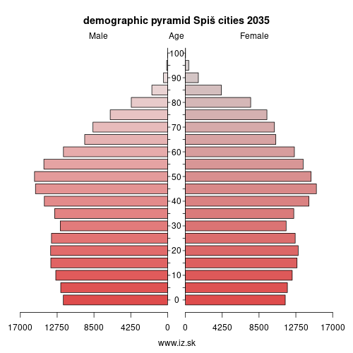
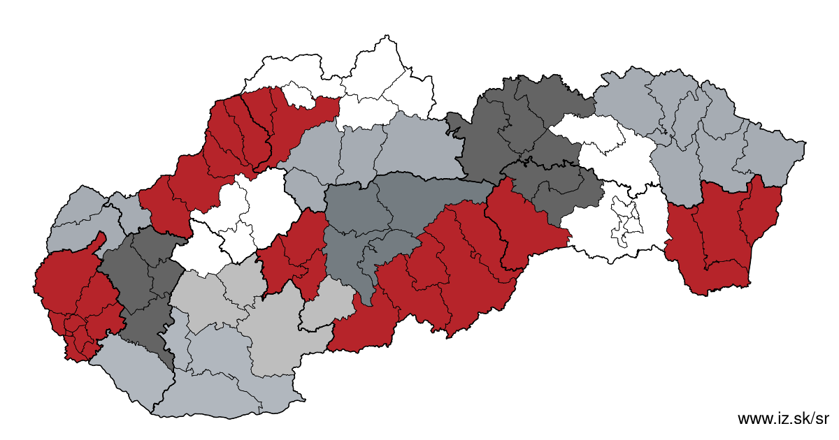
Region Spiš cities
consists of counties:
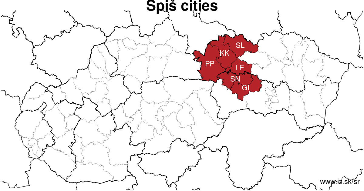
Towns
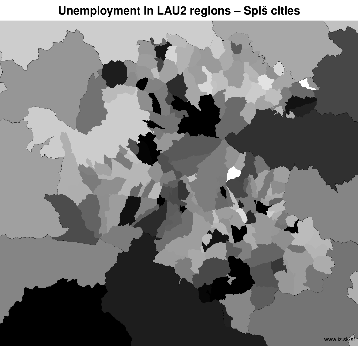
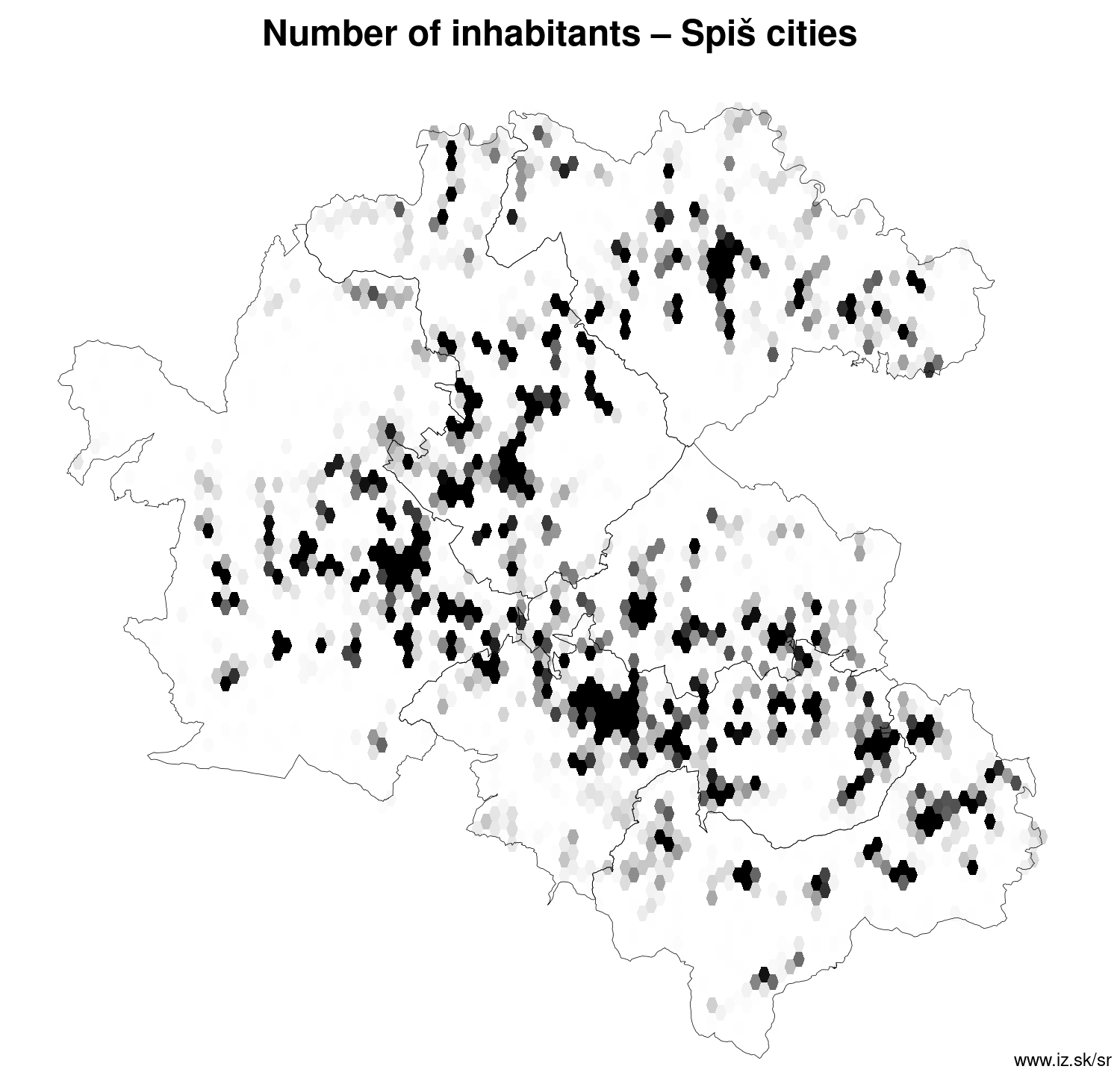
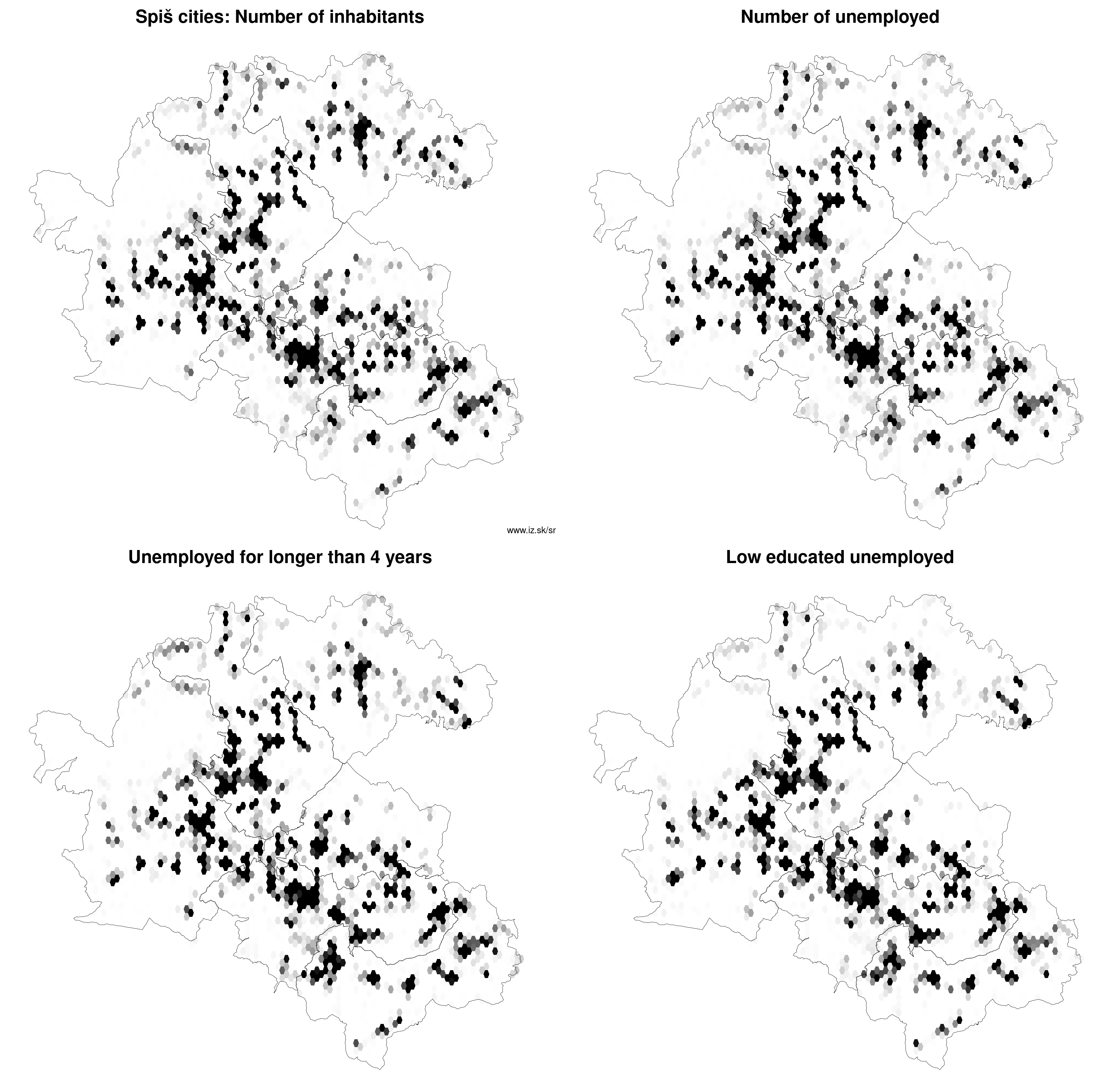
Region Spiš cities contains cities Gelnica, Kežmarok, Krompachy, Levoča, Podolínec, Poprad, Spišská Belá, Spišská Nová Ves, Spišská Stará Ves, Spišské Podhradie, Spišské Vlachy, Stará Ľubovňa, Svit, Vysoké Tatry and 190 villages. More on oma.sk. Statistics on city level on unemployment are for the period of 2024-02-01, for population are fore yar 2021.
name | number of inhabitants in economically active age | number of unemployed number of unemployed women number of long-term unemployed | unemployment rate unemployment rate of women long-term unemployment rate |
|---|---|---|---|
 Poprad | 49 430 33 127 | 1 149 561 421 | 3.5 % 3.3 % 1.3 % |
 Spišská Nová Ves | 35 138 22 958 | 1 010 521 376 | 4.4 % 4.5 % 1.6 % |
 Stará Ľubovňa | 15 832 10 774 | 611 303 228 | 5.7 % 5.7 % 2.1 % |
 Kežmarok | 15 379 10 476 | 526 259 199 | 5 % 4.9 % 1.9 % |
 Levoča | 14 151 9 597 | 633 339 310 | 6.6 % 7.2 % 3.2 % |
 Krompachy | 8 689 5 561 | 319 163 142 | 5.7 % 5.9 % 2.6 % |
 Svit | 7 703 4 902 | 155 87 40 | 3.2 % 3.5 % 0.8 % |
 Spišská Belá | 6 704 4 583 | 309 155 134 | 6.7 % 6.9 % 2.9 % |
 Gelnica | 5 886 4 017 | 183 75 80 | 4.6 % 3.8 % 2 % |
 Vysoké Tatry | 3 851 2 454 | 54 25 19 | 2.2 % 2.1 % 0.8 % |
 Spišské Podhradie | 3 775 2 589 | 146 86 85 | 5.6 % 6.7 % 3.3 % |
 Spišské Vlachy | 3 362 2 248 | 102 50 45 | 4.5 % 4.6 % 2 % |
 Podolínec | 3 060 2 102 | 97 52 30 | 4.6 % 4.9 % 1.4 % |
 Spišská Stará Ves | 2 208 1 464 | 75 34 31 | 5.1 % 4.8 % 2.1 % |
Villages with over 2000 inhabitants are Smižany (8796), Lendak (5454), Veľká Lomnica (5188), Rudňany (4846), Markušovce (4669), Ľubica (4477), Bystrany (3870), Nálepkovo (3684), Štrba (3382), Lomnička (3333), Richnava (3269), Rakúsy (3264), Prakovce (3244), Hranovnica (3193), Huncovce (3078), Nová Ľubovňa (3026), Jakubany (2847), Podhorany (2805), Spišský Štiavnik (2722), Žehra (2649), Hrabušice (2598), Spišský Štvrtok (2580), Batizovce (2500), Spišské Bystré (2487), Liptovská Teplička (2403), Stráne pod Tatrami (2348), Krížová Ves (2317), Letanovce (2281), Spišská Teplica (2259), Spišské Tomášovce (2167), Hôrka (2132), Švedlár (2104), Toporec (2012).
| villages by number of inhabitants | ||||||
|---|---|---|---|---|---|---|
| total | up to 300 | 300 to 500 | 500 to 1000 | 1000 to 1500 | over 1500 | |
| 190 | 48 | 22 | 47 | 21 | 51 | |
Unemployment
| rok | 2012 | 2014 | 2016 | 2018 | 2019 | 2020 | 2021 | 2022 | 2023 |
|---|---|---|---|---|---|---|---|---|---|
| number of unemployed | 38 552 | 36 164 | 30 042 | 19 693 | 18 307 | 21 036 | 21 596 | 19 315 | 18 438 |
| number of long-term unemployed | 21 379 | 21 833 | 16 719 | 9237 | 7697 | 8439 | 10 438 | 9495 | 8887 |
| number of people receiving social benefits | 46 702 | 42 604 | 33 642 | 25 794 | 24 406 | 24 173 | 21 623 | 23 694 | 24 653 |
| number of activational workers | |||||||||
| unemployment rate | 14.2 | 13.3 | 11.1 | 7.4 | 6.9 | 7.9 | 8.4 | 7.5 | 7.2 |
| long-term unemployment rate | 7.9 | 8.0 | 6.2 | 3.4 | 2.9 | 3.2 | 4.0 | 3.7 | 3.5 |
Demographics
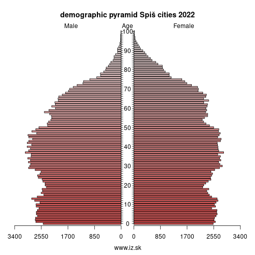
| 2012 | 2014 | 2016 | 2018 | 2019 | 2020 | 2021 | 2022 | 2023 | |
|---|---|---|---|---|---|---|---|---|---|
| number of inhabitants | 391 810 | 394 207 | 396 562 | 398 913 | 399 961 | 401 088 | 393 019 | 393 363 | 393 363 |
| assignation tax | 97 702 749 | 98 660 730 | 119 850 260 | 143 289 860 | 162 656 004 | 168 388 697 | 162 680 441 | 183 146 599 | 204 761 572 |
| demographic dependency | 16.9 | 18.1 | 19.8 | 21.5 | 22.4 | 23.3 | 24.0 | 24.8 | 24.5 |
| number of employed foreigners | 265 | 282 | 390 | 902 | 1117 | 1063 | 890 | 1333 | 1427 |
Number of unemployed
| rok | 2012 | 2014 | 2016 | 2018 | 2019 | 2020 | 2021 | 2022 | 2023 |
|---|---|---|---|---|---|---|---|---|---|
| less than 24 years | 9924 | 7280 | 5480 | 3163 | 2968 | 3550 | 3373 | 2884 | 2800 |
| 25 to 39 years | 16 653 | 13 584 | 11 272 | 7198 | 6682 | 7657 | 7642 | 7020 | 6659 |
| 40 to 54 years | 13 908 | 11 683 | 9902 | 6617 | 6064 | 6790 | 7209 | 6376 | 6128 |
| 55 years and more | 3686 | 3617 | 3387 | 2715 | 2594 | 3038 | 3373 | 3035 | 2851 |
Other regions
- Basic data on Slovak regions
- Labour market indicators of slovak regions.
- Region Bratislava and surroundings
- Region Kopanice
- Region Danube river
- Region lower Vah river
- Region middle Vár river
- Region upper Nitra river
- Region lower Nitra river
- Region Mining cities
- Region Kysuce a Orava
- Region upper Vah river – Liptov
- Region Spiš cities
- Region upper Hron river
- Region Juhoslovenská kotlina
- Region Košice fold and Torysa river
- Region upper Zemplín
- Region lower Zemplín
Suggested citation: Michal Páleník: Regions of Slovakia - Region Spiš cities, IZ Bratislava, retrieved from: https://www.iz.sk/en/projects/regions-of-slovakia/spis-cities
Regions of the Slovak Republic
Due to the need of analysis we have created regions of Slovakia. We will bring more information about these regions from the macroeconomic point of view as well as from the point of view of the labour market.. . .
 Share
Share Facebook
 Twitter
 News
News