Lancashire – UKD4
EU regions: United Kingdom > North West England > Lancashire
| Indicator | Period | Value |
|---|---|---|
| Life long learning | ||
| life long learning participation | 2019 | 13.6 |
| Part time jobs and flexible employment | ||
| percentage of part time workers | 2019 | 25.08 |
| percentage of part time workers, men | 2019 | 11.16 |
| percentage of part time workers, women | 2019 | 40.63 |
| Gender differences | ||
| gender gap in employment rate | 2019 | 89.88 |
| gender gap in unemployment rate | 2019 | 73.81 |
| Graduates and young people | ||
| unemployment rate of youth with elementary education | 2014 | 32.8 |
| NEET | 2019 | 13.7 |
| Employment | ||
| employment rate | 2019 | 74.1 |
More on wikipedia wikidata Q23077 on OpenStreetMap Lancashire slovensky: UKD4
Subregions: Blackburn with Darwen, Blackpool, Lancaster and Wyre, Mid Lancashire, East Lancashire, Chorley and West Lancashire
Unemployment
| Indicator | Period | Value |
|---|---|---|
| Unemployment | ||
| unemployment rate | 2019 | 3.7 |
| youth unemployment rate | 2019 | 11.5 |
| Long term unemployment | ||
| long term unemployment | 2019 | 1.3 |
| share of long term unemployed | 2019 | 34.6 |
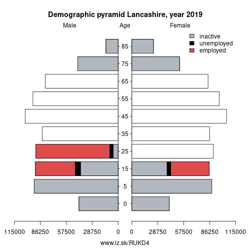
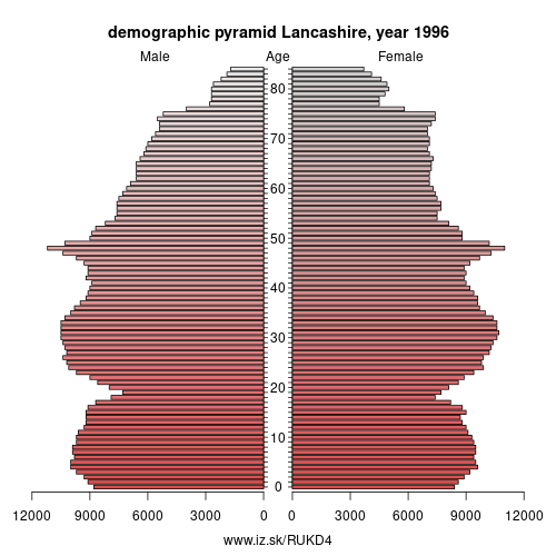
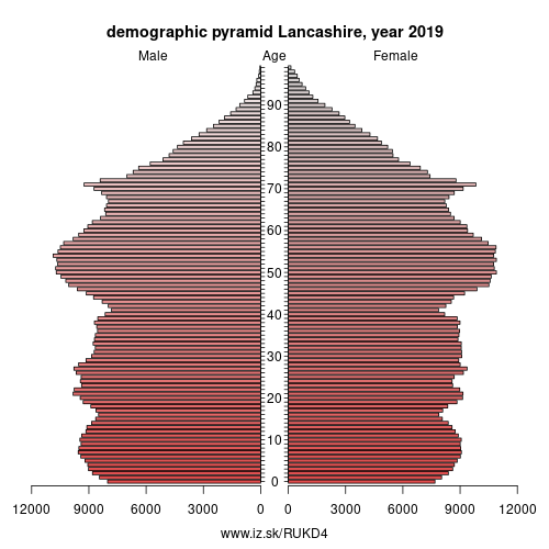
Demographics
| Indicator | Period | Value |
|---|---|---|
| Demographics | ||
| number of inhabitants | 2019 | 1.495318e+06 |
| population density | 2018 | 485.5 |
| old-age dependency ratio | 2019 | 32.3 |
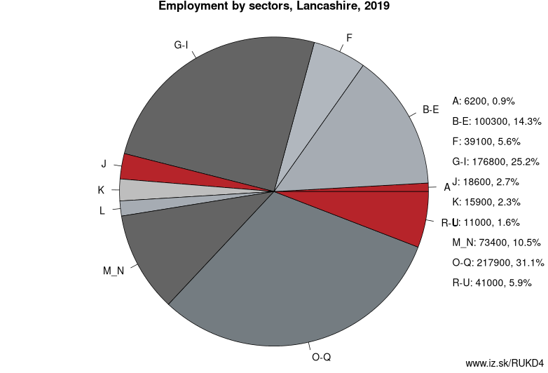
Employment by sectors, Lancashire
| NACE r2 | % | NACE r2 | % | ||
|---|---|---|---|---|---|
| A | 6.2 | 1 % | B-E | 100.3 | 14 % |
| F | 39.1 | 6 % | G-I | 176.8 | 25 % |
| J | 18.6 | 3 % | K | 15.9 | 2 % |
| L | 11 | 2 % | M_N | 73.4 | 10 % |
| O-Q | 217.9 | 31 % | R-U | 41 | 6 % |
| TOTAL | 701.9 | 100 % |
Data for the period year 2019. Source of the data is Eurostat, table [lfst_r_lfe2en2].
Lancashire ( LANG-kə-shər, -sheer; abbreviated Lancs.) is a ceremonial county in North West England. The administrative centre is Preston. The county has a population of 1,449,300 and an area of 1,189 square miles (3,080 km2). People from Lancashire are known as Lancastrians.
The history of Lancashire begins with its founding in the 12th century. In the Domesday Book of 1086, some of its lands were treated as part of Yorkshire. The land that lay between the Ribble and Mersey, Inter Ripam et Mersam, was included in the returns for Cheshire. When its boundaries were established, it bordered Cumberland, Westmorland, Yorkshire, and Cheshire.
Lancashire emerged as a major commercial and industrial region during the Industrial Revolution. Liverpool and Manchester grew into its largest cities, with economies built around the docks and the cotton mills respectively.
Other: North West England, Greater Manchester, Lancashire, Merseyside, Cumbria, Cheshire
Neighbours: Cumbria, West Yorkshire, Greater Manchester, Merseyside, North Yorkshire
Subregions: Blackburn with Darwen, Blackpool, Lancaster and Wyre, Mid Lancashire, East Lancashire, Chorley and West Lancashire
Suggested citation: Michal Páleník: Europe and its regions in numbers - Lancashire – UKD4, IZ Bratislava, retrieved from: https://www.iz.sk/PUKD4, ISBN: 978-80-970204-9-1, DOI:10.5281/zenodo.10200164
 Share
Share Facebook
 Twitter
 News
News