Innsbruck – AT332
EU regions: Austria > Western Austria > Tyrol > Innsbruck
| Indicator | Period | Value |
|---|---|---|
| Gross domestic product | ||
| GDP per capita in PPS of EU average | 2023 | 129 |
Innsbruck slovensky: AT332
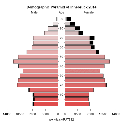
Demographics
| Indicator | Period | Value |
|---|---|---|
| Demographics | ||
| number of inhabitants | 2025 | 319 242 |
| population density | 2024 | 153.3 |
| old-age dependency ratio | 2025 | 29 |
From Wikipedia : Götzens is a community in the district of Innsbruck-Land in Tyrol and lies on a terrace of the highlands above the capital. The nearest neighbouring villages are Axams and Birgitz in the west. The village was founded in 1869.
Other: Tyrol, Innsbruck, Lienz District, Tyrolean Unterland, Reutte district, Tyrolean Oberland
Neighbours: South Tyrol, Tyrolean Unterland, Garmisch-Partenkirchen, Tyrolean Oberland
Suggested citation: Michal Páleník: Europe and its regions in numbers - Innsbruck – AT332, IZ Bratislava, retrieved from: https://www.iz.sk/PAT332, ISBN: 978-80-970204-9-1, DOI:10.5281/zenodo.10200164
https://www.iz.sk/en/projects/eu-regions/AT332
Similar articles
Navigation:
- Short news
- Local Administrative Units data of Visegrad countries open data
- Projects and activities
- European regions
- Random region: Hungary, Central Hungary, Budapest
 Share
Share Facebook
 Twitter
 News
News