Arrondissement of Roeselare – BE256
EU regions: Belgium > Flemish Region > West Flanders > Arrondissement of Roeselare
| Indicator | Period | Value |
|---|---|---|
| Gross domestic product | ||
| GDP per capita in PPS of EU average | 2024 | 122 |
Arrondissement of Roeselare slovensky: BE256
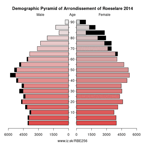
Demographics
| Indicator | Period | Value |
|---|---|---|
| Demographics | ||
| number of inhabitants | 2025 | 160 971 |
| population density | 2024 | 585.3 |
| old-age dependency ratio | 2025 | 34.2 |
Other: West Flanders, Arrondissement of Ypres, Arrondissement of Roeselare, Arrondissement of Tielt, Arrondissement of Bruges, Arrondissement of Diksmuide, Arrondissement of Kortrijk, Arrondissement of Ostend, Arrondissement of Veurne
Neighbours: Arrondissement of Diksmuide, Arrondissement of Ypres, Arrondissement of Tielt, Arrondissement of Kortrijk, Arrondissement of Bruges
Suggested citation: Michal Páleník: Europe and its regions in numbers - Arrondissement of Roeselare – BE256, IZ Bratislava, retrieved from: https://www.iz.sk/PBE256, ISBN: 978-80-970204-9-1, DOI:10.5281/zenodo.10200164
https://www.iz.sk/en/projects/eu-regions/BE256
 Share
Share Facebook
 Twitter
 News
News