Stara Zagora – BG344
EU regions: Bulgaria > Northern and Eastern Bulgaria > Yugoiztochen Planning Region > Stara Zagora
| Indicator | Period | Value |
|---|---|---|
| Gross domestic product | ||
| GDP per capita in PPS of EU average | 2024 | 91 |
Stara Zagora slovensky: BG344
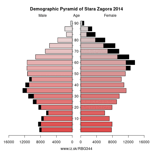
Demographics
| Indicator | Period | Value |
|---|---|---|
| Demographics | ||
| number of inhabitants | 2025 | 288 736 |
| population density | 2024 | 56.8 |
| old-age dependency ratio | 2025 | 40.9 |
Other: Yugoiztochen Planning Region, Burgas, Yambol, Sliven, Stara Zagora
Neighbours: Veliko Tarnovo, Haskovo, Yambol, Sliven, Plovdiv, Gabrovo, Lovech
Suggested citation: Michal Páleník: Europe and its regions in numbers - Stara Zagora – BG344, IZ Bratislava, retrieved from: https://www.iz.sk/PBG344, ISBN: 978-80-970204-9-1, DOI:10.5281/zenodo.10200164
https://www.iz.sk/en/projects/eu-regions/BG344
 Share
Share Facebook
 Twitter
 News
News