Cávado – PT112
EU regions: Portugal > Continental Portugal > Norte Region > Cávado
| Indicator | Period | Value |
|---|---|---|
| Gross domestic product | ||
| GDP per capita in PPS of EU average | 2024 | 70 |
Cávado slovensky: PT112
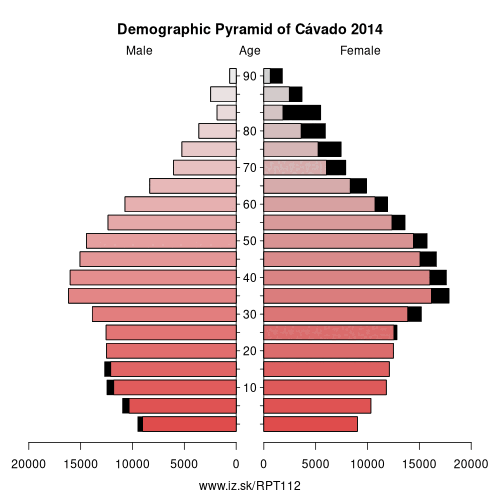
Demographics
| Indicator | Period | Value |
|---|---|---|
| Demographics | ||
| number of inhabitants | 2025 | 433 039 |
| population density | 2024 | 350.2 |
| old-age dependency ratio | 2025 | 32.3 |
From Wikipedia : Dão-Lafões (Portuguese pronunciation: [dɐ̃w̃ lɐˈfõj̃ʃ]) is a former Portuguese NUTS III sub-region in the Centro Region. It was abolished at the January 2015 NUTS 3 revision. It was located in central Portugal, and had an approximate area of 3,483 km² and 286,315 inhabitants. Its largest city was Viseu (with approx. 50,000 inhabitants).
Municipalities
- Aguiar da Beira
- Carregal do Sal
- Castro Daire
- Mangualde
- Mortágua
- Nelas
- Oliveira de Frades
- Penalva do Castelo
- Santa Comba Dão
- São Pedro do Sul
- Sátão
- Tondela
- Vila Nova de Paiva
- Viseu
- Vouzela
Other: Norte Region, Ave, Cávado, Alto Tâmega Subregion, Terras de Trás-os-Montes, Metropolitan Area of Porto, Alto Minho Subregion, Douro Subregion, Tâmega e Sousa subregion
Neighbours: Alto Minho Subregion, Alto Tâmega Subregion, Ave, Metropolitan Area of Porto, Ourense
Suggested citation: Michal Páleník: Europe and its regions in numbers - Cávado – PT112, IZ Bratislava, retrieved from: https://www.iz.sk/PPT112, ISBN: 978-80-970204-9-1, DOI:10.5281/zenodo.10200164
 Share
Share Facebook
 Twitter
 News
News