Metropolitan Area of Porto – PT11A
EU regions: Portugal > Continental Portugal > Norte Region > Metropolitan Area of Porto
| Indicator | Period | Value |
|---|---|---|
| Gross domestic product | ||
| GDP per capita in PPS of EU average | 2024 | 79 |
Metropolitan Area of Porto slovensky: PT11A
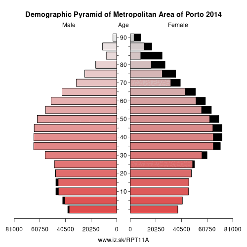
Demographics
| Indicator | Period | Value |
|---|---|---|
| Demographics | ||
| number of inhabitants | 2025 | 1 818 217 |
| population density | 2024 | 893.2 |
| old-age dependency ratio | 2025 | 36.5 |
Other: Norte Region, Ave, Cávado, Alto Tâmega Subregion, Terras de Trás-os-Montes, Metropolitan Area of Porto, Alto Minho Subregion, Douro Subregion, Tâmega e Sousa subregion
Neighbours: Ave, Cávado, Região de Aveiro, Tâmega e Sousa subregion, Viseu Dão Lafões Subregion
Suggested citation: Michal Páleník: Europe and its regions in numbers - Metropolitan Area of Porto – PT11A, IZ Bratislava, retrieved from: https://www.iz.sk/PPT11A, ISBN: 978-80-970204-9-1, DOI:10.5281/zenodo.10200164
https://www.iz.sk/en/projects/eu-regions/PT11A
 Share
Share Facebook
 Twitter
 News
News