Waldviertel – AT124
EU regions: Austria > East Austria > Lower Austria > Waldviertel
| Indicator | Period | Value |
|---|---|---|
| Gross domestic product | ||
| GDP per capita in PPS of EU average | 2023 | 92 |
Waldviertel slovensky: AT124
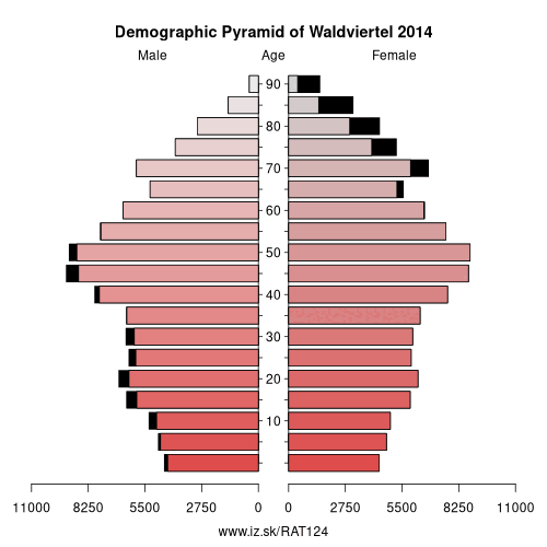
Demographics
| Indicator | Period | Value |
|---|---|---|
| Demographics | ||
| number of inhabitants | 2025 | 215 137 |
| population density | 2024 | 47.3 |
| old-age dependency ratio | 2025 | 39.4 |
From Wikipedia : The Waldviertel (Forest Quarter; Central Bavarian: Woidviadl) is the northwestern region of the northeast Austrian state of Lower Austria. It is bounded to the south by the Danube, to the southwest by Upper Austria, to the northwest and the north by the Czech Republic and to the east by the Manhartsberg (537 m, 1,762 ft), which is the survey point dividing Waldviertel from Weinviertel. Geologically it is a part of the Bohemian Massif.
Further reading
- Birgit Zotz, Das Waldviertel – Zwischen Mystik und Klarheit.
Other: Lower Austria, St. Pölten, Wiener Umland/Nordteil, Wiener Umland/Südteil, Niederösterreich-Süd, Waldviertel, Amstetten District, Weinviertel
Neighbours: Mühlviertel, Amstetten District, Wiener Umland/Nordteil, St. Pölten, South Moravian Region, Weinviertel, South Bohemian Region
Suggested citation: Michal Páleník: Europe and its regions in numbers - Waldviertel – AT124, IZ Bratislava, retrieved from: https://www.iz.sk/PAT124, ISBN: 978-80-970204-9-1, DOI:10.5281/zenodo.10200164
 Share
Share Facebook
 Twitter
 News
News