Weinviertel – AT125
EU regions: Austria > East Austria > Lower Austria > Weinviertel
| Indicator | Period | Value |
|---|---|---|
| Gross domestic product | ||
| GDP per capita in PPS of EU average | 2023 | 74 |
Weinviertel slovensky: AT125
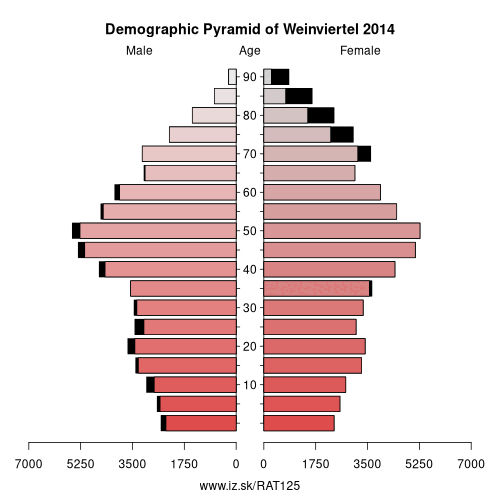
Demographics
| Indicator | Period | Value |
|---|---|---|
| Demographics | ||
| number of inhabitants | 2025 | 127 215 |
| population density | 2024 | 53.3 |
| old-age dependency ratio | 2025 | 38.3 |
From Wikipedia : The Weinviertel ("wine quarter") or Viertel unter dem Manhartsberg ("area below the Manhartsberg") is located in the northeast of Lower Austria.
In the east, the Weinviertel borders Slovakia at the March River. In the south, it borders Mostviertel and Industrieviertel, its limits being the Wagram, the Danube and the Marchfeld. Its western neighbor is Waldviertel, the traditional border being the Manhartsberg. In the north, the Weinviertel is adjacent to the Czech Republic, more specifically Moravia. The river Thaya runs back and forth across the border.
Viticulture
The name Weinviertel is derived from viticulture; it is Austria's largest wine growing area. The most important grape varieties are:
- Grüner Veltliner
- Pinot blanc
- Welschriesling
- Zweigelt
- Blauer Portugieser
Geography
Other important rivers are Göllersbach, Hamelbach, Pulkau, Rußbach, Schmida, Waidenbach, Weidenbach and Zaya.
Beside viticulture and agriculture, other industries contribute to the Weinviertel economy. Most notably, there are some oil fields in its eastern part, which are exploited by OMV and located in the „oil communities" of Neusiedl an der Zaya, Zistersdorf, Matzen, Auersthal and Prottes.
Other: Lower Austria, St. Pölten, Wiener Umland/Nordteil, Wiener Umland/Südteil, Niederösterreich-Süd, Waldviertel, Amstetten District, Weinviertel
Neighbours: Trnava Region, Wiener Umland/Nordteil, South Moravian Region, Bratislava Region, Waldviertel
Suggested citation: Michal Páleník: Europe and its regions in numbers - Weinviertel – AT125, IZ Bratislava, retrieved from: https://www.iz.sk/PAT125, ISBN: 978-80-970204-9-1, DOI:10.5281/zenodo.10200164
 Share
Share Facebook
 Twitter
 News
News