Canton of Solothurn – CH023
EU regions: Switzerland > SCHWEIZ/SUISSE/SVIZZERA > Espace Mittelland > Canton of Solothurn
| Indicator | Period | Value |
|---|
Canton of Solothurn slovensky: CH023
Demographics
| Indicator | Period | Value |
|---|---|---|
| Demographics | ||
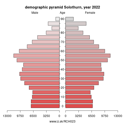
| number of inhabitants | 2025 | 289 792 |
| population density | 2024 | 366.8 |
| old-age dependency ratio | 2025 | 33.1 |
Other: Espace Mittelland, Canton of Neuchâtel, Canton of Fribourg, Canton of Berne, Canton of Solothurn, Canton of Jura
Neighbours: Canton of Jura, Haut-Rhin, Canton of Basel-Landschaft, Canton of Berne, Canton of Aargau
Suggested citation: Michal Páleník: Europe and its regions in numbers - Canton of Solothurn – CH023, IZ Bratislava, retrieved from: https://www.iz.sk/PCH023, ISBN: 978-80-970204-9-1, DOI:10.5281/zenodo.10200164
https://www.iz.sk/en/projects/eu-regions/CH023
 Share
Share Facebook
 Twitter
 News
News