Canton of Basel-Landschaft – CH032
EU regions: Switzerland > SCHWEIZ/SUISSE/SVIZZERA > Northwestern Switzerland > Canton of Basel-Landschaft
| Indicator | Period | Value |
|---|
Canton of Basel-Landschaft slovensky: CH032
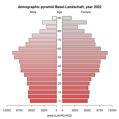
Demographics
| Indicator | Period | Value |
|---|---|---|
| Demographics | ||
| number of inhabitants | 2025 | 301 323 |
| population density | 2024 | 581.6 |
| old-age dependency ratio | 2025 | 37.2 |
From Wikipedia : Basel-Landschaft (; German: (Kanton) Basel-Landschaft [ˈkantɔn ˌbaːzl̩ ˈlantʃaft] (listen)) or Basle-Country, informally known as Baselland or Baselbiet, is one of the 26 cantons forming the Swiss Confederation. It is composed of five districts and its capital city is Liestal. It is traditionally considered a "half-canton“, the other half being Basel-Stadt, its urban counterpart.
Basel-Landschaft is one of the northernmost cantons of Switzerland. It lies essentially south of the Rhine and north of the Jura Mountains. The canton shares borders with the canton of Basel-Stadt to the north, the canton of Aargau to the east, the canton of Solothurn to the south and the canton of Jura to the west. It shares international borders as well with France and Germany to the north.
Together with Basel-Stadt, Basel-Landschaft was part of the canton of Basel, who joined the Old Swiss Confederacy in 1501. Political quarrels and armed conflict led to the partition of the canton in 1833.
History
Basel-Landschaft, together with Basel-Stadt, formed the historic Canton of Basel until they separated following the uprising of 1833 (Battle of the Hülftenschanz near Frenkendorf).
Other: Northwestern Switzerland, Canton of Basel-Stadt, Canton of Basel-Landschaft, Canton of Aargau
Neighbours: Canton of Solothurn, Canton of Jura, Lörrach, Haut-Rhin, Canton of Basel-Stadt, Canton of Aargau
Suggested citation: Michal Páleník: Europe and its regions in numbers - Canton of Basel-Landschaft – CH032, IZ Bratislava, retrieved from: https://www.iz.sk/PCH032, ISBN: 978-80-970204-9-1, DOI:10.5281/zenodo.10200164
 Share
Share Facebook
 Twitter
 News
News