Rheintal-Bodenseegebiet – AT342
EU regions: Austria > Western Austria > Vorarlberg > Rheintal-Bodenseegebiet
| Indicator | Period | Value |
|---|---|---|
| Gross domestic product | ||
| GDP per capita in PPS of EU average | 2023 | 119 |
Rheintal-Bodenseegebiet slovensky: AT342
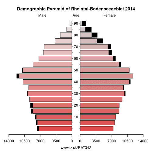
Demographics
| Indicator | Period | Value |
|---|---|---|
| Demographics | ||
| number of inhabitants | 2025 | 316 755 |
| population density | 2024 | 465.9 |
| old-age dependency ratio | 2025 | 28.4 |
Other: Vorarlberg, Rheintal-Bodenseegebiet, Bludenz-Bregenzer Wald
Neighbours: Canton of St. Gallen, Lindau, Liechtenstein, Bludenz-Bregenzer Wald, Oberallgäu, Bodenseekreis
Suggested citation: Michal Páleník: Europe and its regions in numbers - Rheintal-Bodenseegebiet – AT342, IZ Bratislava, retrieved from: https://www.iz.sk/PAT342, ISBN: 978-80-970204-9-1, DOI:10.5281/zenodo.10200164
https://www.iz.sk/en/projects/eu-regions/AT342
 Share
Share Facebook
 Twitter
 News
News