Vorarlberg – AT34
EU regions: Austria > Western Austria > Vorarlberg
| Indicator | Period | Value |
|---|---|---|
| Life long learning | ||
| life long learning participation | 2025 | 14.3 |
| Part time jobs and flexible employment | ||
| percentage of part time workers | 2025 | 34.87 |
| percentage of part time workers, men | 2025 | 12.23 |
| percentage of part time workers, women | 2025 | 60.7 |
| Gender differences | ||
| gender gap in employment rate | 2025 | 88.47 |
| gender gap in unemployment rate | 2025 | 95.45 |
| Graduates and young people | ||
| NEET | 2025 | 9.3 |
| Gross domestic product | ||
| GDP per capita in PPS of EU average | 2024 | 125 |
| Employment | ||
| employment rate | 2025 | 76.8 |
| Social exclusion | ||
| people at risk of poverty or social exclusion | 2018 | 21.9 |
Vorarlberg slovensky: AT34
Subregions: Bludenz-Bregenzer Wald, Rheintal-Bodenseegebiet
Unemployment
| Indicator | Period | Value |
|---|---|---|
| Unemployment | ||
| unemployment rate | 2025 | 4.4 |
| youth unemployment rate | 2009 | 11.6 |
Demographics

| Indicator | Period | Value |
|---|---|---|
| Demographics | ||
| number of inhabitants | 2025 | 411 784 |
| population density | 2024 | 162.3 |
| old-age dependency ratio | 2025 | 28.8 |
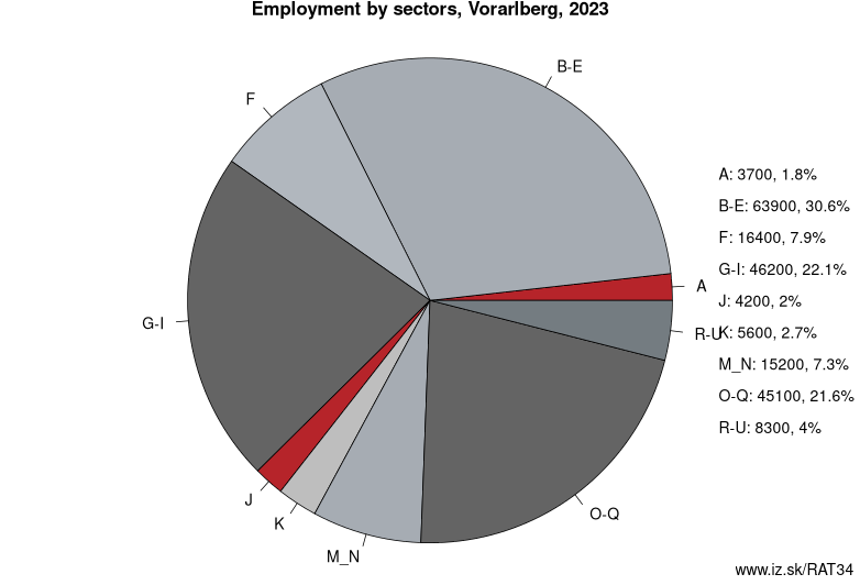
Employment by sectors, Vorarlberg
| NACE r2 | % | NACE r2 | % | ||
|---|---|---|---|---|---|
| A | 3.3 | 2% | B-E | 53.8 | 26% |
| F | 15.8 | 8% | G-I | 49.9 | 24% |
| J | 4 | 2% | K | 6.6 | 3% |
| M_N | 19.4 | 9% | O-Q | 46.7 | 22% |
| R-U | 7.5 | 4% | TOTAL | 208.4 | 100% |
Data for the period year 2025. Source of the data is Eurostat, table [lfst_r_lfe2en2].
From Wikipedia :
Vorarlberg (German pronunciation: [ˈfoːɐ̯ʔarlbɛrk]) is the westernmost federal state (Bundesland) of Austria. It has the second-smallest area after Vienna, and although it has the second-smallest population, it also has the second-highest population density (also after Vienna). It borders three countries: Germany (Bavaria and Baden-Württemberg via Lake Constance), Switzerland (Grisons and St. Gallen), and Liechtenstein. The only Austrian state that shares a border with Vorarlberg is Tyrol to the east.The capital of Vorarlberg is Bregenz (29,806 inhabitants), although Dornbirn (49,278 inhabitants) and Feldkirch (33,420 inhabitants) have larger populations. Vorarlberg is also the only state in Austria where the local dialect is not Austro-Bavarian, but rather an Alemannic dialect; it therefore has much more in common culturally with (historically) Alemannic-speaking German-speaking Switzerland, Liechtenstein, Swabia, and Alsace than with the rest of Austria, southeastern Bavaria, and South Tyrol.
Vorarlberg is almost completely mountainous and has been nicknamed the ‘Ländle’ meaning ‘small land’.
Geography
The main rivers in Vorarlberg are the Ill (running through the Montafon and Walgau valleys into the Rhine), the Rhine (forming the border with Switzerland), the Bregenzer Ache and the Dornbirner Ach. One of the shortest rivers is the Galina.
Other: Western Austria, Tyrol, Salzburg, Vorarlberg, Upper Austria
Neighbours: Swabia, Eastern Switzerland, Liechtenstein, Tyrol, Tübingen Government Region
Subregions: Bludenz-Bregenzer Wald, Rheintal-Bodenseegebiet
Suggested citation: Michal Páleník: Europe and its regions in numbers - Vorarlberg – AT34, IZ Bratislava, retrieved from: https://www.iz.sk/PAT34, ISBN: 978-80-970204-9-1, DOI:10.5281/zenodo.10200164
 Share
Share Facebook
 Twitter
 News
News