Canton of St. Gallen – CH055
EU regions: Switzerland > SCHWEIZ/SUISSE/SVIZZERA > Eastern Switzerland > Canton of St. Gallen
| Indicator | Period | Value |
|---|
Canton of St. Gallen slovensky: CH055
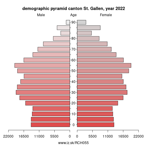
Demographics
| Indicator | Period | Value |
|---|---|---|
| Demographics | ||
| number of inhabitants | 2025 | 540 036 |
| population density | 2024 | 276.1 |
| old-age dependency ratio | 2025 | 30 |
Other: Eastern Switzerland, Canton of Appenzell Innerrhoden, Canton of Glarus, Canton of Appenzell Ausserrhoden, Canton of St. Gallen, Canton of Thurgau, Canton of Schaffhausen, Canton of the Grisons
Neighbours: Bodenseekreis, Canton of Appenzell Ausserrhoden, Canton of Zürich, Canton of the Grisons, Canton of Schwyz, Canton of Glarus, Canton of Thurgau, Lindau, Canton of Appenzell Innerrhoden, Rheintal-Bodenseegebiet, Liechtenstein
Suggested citation: Michal Páleník: Europe and its regions in numbers - Canton of St. Gallen – CH055, IZ Bratislava, retrieved from: https://www.iz.sk/PCH055, ISBN: 978-80-970204-9-1, DOI:10.5281/zenodo.10200164
 Share
Share Facebook
 Twitter
 News
News