Nišava District – RS225
EU regions: Serbia > Serbia-South > Southern and Eastern Serbia > Nišava District
| Indicator | Period | Value |
|---|---|---|
| Gross domestic product | ||
| GDP per capita in PPS of EU average | 2023 | 36 |
Nišava District slovensky: RS225
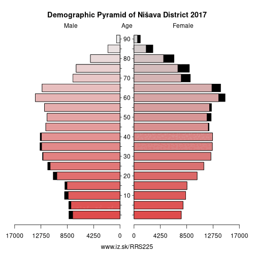
Demographics
| Indicator | Period | Value |
|---|---|---|
| Demographics | ||
| number of inhabitants | 2025 | 340 169 |
| population density | 2019 | 132.5 |
| old-age dependency ratio | 2025 | 36.6 |
Other: Southern and Eastern Serbia, Zaječar District, Jablanica District, Bor District, Braničevo District, Nišava District, Toplica District, Podunavlje District, Pirot District, Pčinja District
Neighbours: Toplica District, Rasina District, Zaječar District, Pirot District, Jablanica District, Pomoravlje District
Suggested citation: Michal Páleník: Europe and its regions in numbers - Nišava District – RS225, IZ Bratislava, retrieved from: https://www.iz.sk/PRS225, ISBN: 978-80-970204-9-1, DOI:10.5281/zenodo.10200164
https://www.iz.sk/en/projects/eu-regions/RS225
 Share
Share Facebook
 Twitter
 News
News