Kahramanmaraş Province – TR632
EU regions: Turkey > Mediterranean Region (statistical) > Hatay Subregion > Kahramanmaraş Province
| Indicator | Period | Value |
|---|---|---|
| Gross domestic product | ||
| GDP per capita in PPS of EU average | 2024 | 47 |
Kahramanmaraş Province slovensky: TR632
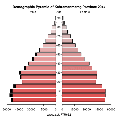
Demographics
| Indicator | Period | Value |
|---|---|---|
| Demographics | ||
| number of inhabitants | 2025 | 1 134 105 |
| population density | 2024 | 78.6 |
| old-age dependency ratio | 2025 | 14.5 |
From Wikipedia : Uecker-Randow was a Kreis (district) in the eastern part of Mecklenburg-Western Pomerania, Germany. Neighboring districts were (from south clockwise) Uckermark in Brandenburg, Mecklenburg-Strelitz and Ostvorpommern. To the east was the West Pomeranian Voivodship of Poland.
History
Uecker-Randow District was established on 12 June 1994 by merging the previous districts of Pasewalk and Ueckermünde, along with part of the district of Strasburg. On 4 September 2011, it was merged into Vorpommern-Greifswald.
Other: Hatay Subregion, Osmaniye Province, Hatay Province, Kahramanmaraş Province
Neighbours: Malatya Province, Kayseri Province, Osmaniye Province, Adıyaman Province, Gaziantep Province, Şırnak Province, Adana Province
Suggested citation: Michal Páleník: Europe and its regions in numbers - Kahramanmaraş Province – TR632, IZ Bratislava, retrieved from: https://www.iz.sk/PTR632, ISBN: 978-80-970204-9-1, DOI:10.5281/zenodo.10200164
 Share
Share Facebook
 Twitter
 News
News