Bayburt Province – TRA13
EU regions: Turkey > Northeast Anatolia Region (statistical) > Erzurum Subregion > Bayburt Province
| Indicator | Period | Value |
|---|---|---|
| Gross domestic product | ||
| GDP per capita in PPS of EU average | 2024 | 46 |
Bayburt Province slovensky: TRA13
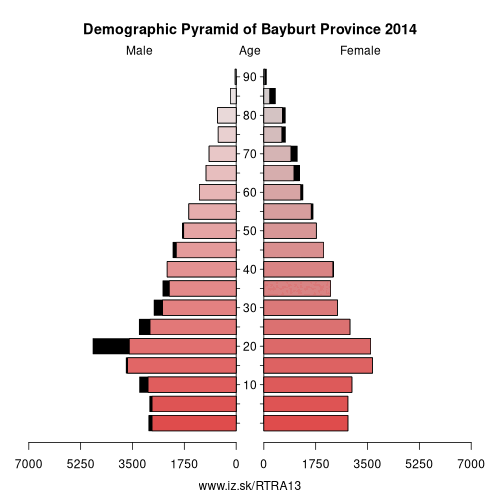
Demographics
| Indicator | Period | Value |
|---|---|---|
| Demographics | ||
| number of inhabitants | 2025 | 83 676 |
| population density | 2024 | 22.7 |
| old-age dependency ratio | 2025 | 18.3 |
From Wikipedia : Ostvorpommern was a Kreis (district) in the eastern part of Mecklenburg-Vorpommern, Germany. Neighboring districts were (from east clockwise) Uecker-Randow, Mecklenburg-Strelitz, Demmin and Nordvorpommern. The Hanseatic city of Greifswald was enclosed by the district, but did not belong to it.
History
Ostvorpommern District was established on June 12, 1994 by merging the former districts of Anklam, Greifswald and Wolgast. It was merged into Vorpommern-Greifswald on 4 September 2011.
Other: Erzurum Subregion, Erzurum Province, Erzincan Province, Bayburt Province
Neighbours: Gümüşhane Province, Rize Province, Erzincan Province, Trabzon Province, Erzurum Province
Suggested citation: Michal Páleník: Europe and its regions in numbers - Bayburt Province – TRA13, IZ Bratislava, retrieved from: https://www.iz.sk/PTRA13, ISBN: 978-80-970204-9-1, DOI:10.5281/zenodo.10200164
 Share
Share Facebook
 Twitter
 News
News