Liverpool – UKD72
EU regions: United Kingdom > North West England > Merseyside > Liverpool
| Indicator | Period | Value |
|---|
Liverpool slovensky: UKD72
Demographics
| Indicator | Period | Value |
|---|---|---|
| Demographics | ||
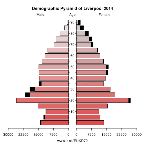
| number of inhabitants | 2019 | 496 784 |
| population density | 2018 | 4421.5 |
| old-age dependency ratio | 2019 | 21.4 |
From Wikipedia :
Liverpool is a city and metropolitan borough in North West England, with an estimated population of 491,500. Its metropolitan area is the fifth-largest in the UK, with a population of 2.24 million in 2011. The local authority is Liverpool City Council, the most populous local government district in the metropolitan county of Merseyside and the largest in the Liverpool City Region.Liverpool is on the eastern side of the Mersey Estuary, and historically lay within the ancient hundred of West Derby in the southwest of the county of Lancashire. It became a borough in 1207 and a city in 1880. In 1889, it became a county borough independent of Lancashire. Its growth as a major port was paralleled by the expansion of the city throughout the Industrial Revolution. Along with handling general cargo, freight, and raw materials such as coal and cotton, the city merchants were involved in the Atlantic slave trade. In the 19th century, it was a major port of departure for Irish and English emigrants to North America. Liverpool was home to both the Cunard and White Star Line, and was the port of registry of the ocean liner RMS Titanic, the RMS Lusitania, RMS Queen Mary, and RMS Olympic.
Other: Merseyside, East Merseyside, Liverpool, Sefton, Wirral
Neighbours: Sefton, East Merseyside
Suggested citation: Michal Páleník: Europe and its regions in numbers - Liverpool – UKD72, IZ Bratislava, retrieved from: https://www.iz.sk/PUKD72, ISBN: 978-80-970204-9-1, DOI:10.5281/zenodo.10200164
 Share
Share Facebook
 Twitter
 News
News