Merseyside – UKD7
EU regions: United Kingdom > North West England > Merseyside
| Indicator | Period | Value |
|---|---|---|
| Life long learning | ||
| life long learning participation | 2019 | 13 |
| Part time jobs and flexible employment | ||
| percentage of part time workers | 2019 | 21.16 |
| percentage of part time workers, men | 2019 | 7.57 |
| percentage of part time workers, women | 2019 | 34.49 |
| Gender differences | ||
| gender gap in employment rate | 2019 | 95.63 |
| gender gap in unemployment rate | 2019 | 67.39 |
| Graduates and young people | ||
| unemployment rate of youth with elementary education | 2014 | 33.3 |
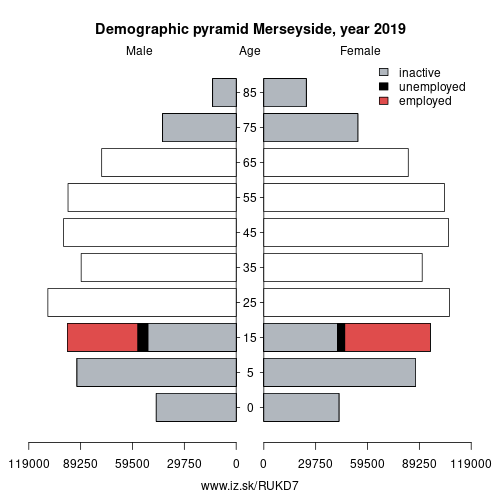
| NEET | 2019 | 13.2 |
| Employment | ||
| employment rate | 2019 | 71.5 |
Merseyside slovensky: UKD7
Subregions: East Merseyside, Liverpool, Sefton, Wirral
Unemployment
| Indicator | Period | Value |
|---|---|---|
| Unemployment | ||
| unemployment rate | 2019 | 3.9 |
| youth unemployment rate | 2019 | 10.4 |
| Long term unemployment | ||
| long term unemployment | 2019 | 1 |
| share of long term unemployed | 2019 | 26.9 |
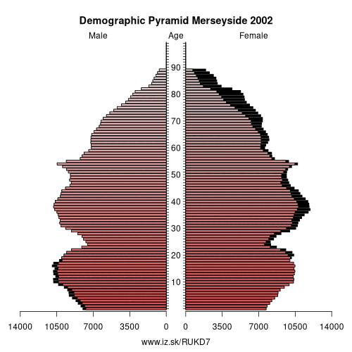
Demographics
| Indicator | Period | Value |
|---|---|---|
| Demographics | ||
| number of inhabitants | 2019 | 1 553 324 |
| population density | 2018 | 2135.6 |
| old-age dependency ratio | 2019 | 29.6 |
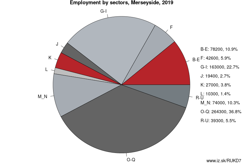
Employment by sectors, Merseyside
| NACE r2 | % | NACE r2 | % | ||
|---|---|---|---|---|---|
| B-E | 78.2 | 11% | F | 42.6 | 6% |
| G-I | 163 | 23% | J | 19.4 | 3% |
| K | 27 | 4% | L | 10.3 | 1% |
| M_N | 74 | 10% | O-Q | 264.3 | 37% |
| R-U | 39.3 | 5% | TOTAL | 720.7 | 100% |
Data for the period year 2019. Source of the data is Eurostat, table [lfst_r_lfe2en2].
From Wikipedia :
Merseyside ( MUR-zee-syde) is a metropolitan county in North West England, with a population of 1.38 million. It encompasses the metropolitan area centred on both banks of the lower reaches of the Mersey Estuary and comprises five metropolitan boroughs: Knowsley, St Helens, Sefton, Wirral, and the city of Liverpool. Merseyside, which was created on 1 April 1974 as a result of the Local Government Act 1972, takes its name from the River Mersey.Merseyside spans 249 square miles (645 km2) of land which border Lancashire (to the north-east), Greater Manchester (to the east), Cheshire (to the south and south-east) and the Irish Sea to the west. North Wales is across the Dee Estuary. There is a mix of high density urban areas, suburbs, semi-rural and rural locations in Merseyside, but overwhelmingly the land use is urban. It has a focused central business district, formed by Liverpool City Centre, but Merseyside is also a polycentric county with five metropolitan districts, each of which has at least one major town centre and outlying suburbs. The Liverpool Urban Area is the fifth most populous conurbation in England, and dominates the geographic centre of the county, while the smaller Birkenhead Urban Area dominates the Wirral Peninsula in the south.
For the 12 years following 1974 the county had a two-tier system of local government; district councils shared power with the Merseyside County Council. The county council was abolished in 1986, and so its districts (the metropolitan boroughs) are now effectively unitary authority areas.
Other: North West England, Greater Manchester, Merseyside, Cumbria, Lancashire, Cheshire
Neighbours: Cheshire, Lancashire, Greater Manchester
Subregions: East Merseyside, Liverpool, Sefton, Wirral
Suggested citation: Michal Páleník: Europe and its regions in numbers - Merseyside – UKD7, IZ Bratislava, retrieved from: https://www.iz.sk/PUKD7, ISBN: 978-80-970204-9-1, DOI:10.5281/zenodo.10200164
 Share
Share Facebook
 Twitter
 News
News