Cheshire – UKD6
EU regions: United Kingdom > North West England > Cheshire
| Indicator | Period | Value |
|---|---|---|
| Life long learning | ||
| life long learning participation | 2019 | 13.6 |
| Part time jobs and flexible employment | ||
| percentage of part time workers | 2019 | 23.75 |
| percentage of part time workers, men | 2019 | 11.06 |
| percentage of part time workers, women | 2019 | 38.18 |
| Gender differences | ||
| gender gap in employment rate | 2019 | 87.71 |
| gender gap in unemployment rate | 2019 | 90.91 |
| Graduates and young people | ||
| unemployment rate of youth with elementary education | 2010 | 27.8 |
| NEET | 2019 | 13.6 |
| Employment | ||
| employment rate | 2019 | 77.8 |
Cheshire slovensky: UKD6
Subregions: Warrington, Cheshire East, Cheshire West and Chester
Unemployment
| Indicator | Period | Value |
|---|---|---|
| Unemployment | ||
| unemployment rate | 2019 | 3.3 |
| youth unemployment rate | 2019 | 10.8 |
| Long term unemployment | ||
| long term unemployment | 2015 | 0.9 |
| share of long term unemployed | 2015 | 26.8 |
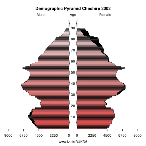
Demographics
| Indicator | Period | Value |
|---|---|---|
| Demographics | ||
| number of inhabitants | 2019 | 931 347 |
| population density | 2018 | 410.6 |
| old-age dependency ratio | 2019 | 34.9 |
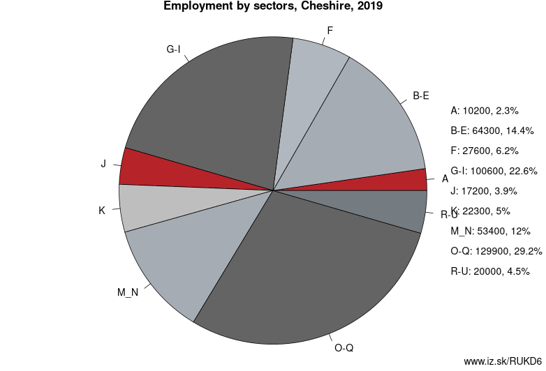
Employment by sectors, Cheshire
| NACE r2 | % | NACE r2 | % | ||
|---|---|---|---|---|---|
| A | 10.2 | 2% | B-E | 64.3 | 14% |
| F | 27.6 | 6% | G-I | 100.6 | 22% |
| J | 17.2 | 4% | K | 22.3 | 5% |
| M_N | 53.4 | 12% | O-Q | 129.9 | 29% |
| R-U | 20 | 4% | TOTAL | 450.4 | 100% |
Data for the period year 2019. Source of the data is Eurostat, table [lfst_r_lfe2en2].
From Wikipedia :
Cheshire (Welsh: Sir Gaer) CHESH-ər, -eer; archaically the County Palatine of Chester) is a county in North West England, bordering Merseyside and Greater Manchester to the north, Derbyshire to the east, Staffordshire and Shropshire to the south and Flintshire, Wales and Wrexham county borough to the west. Cheshire's county town is the City of Chester (118,200); the largest town is Warrington (209,700). Other major towns include Crewe (71,722), Ellesmere Port (55,715), Macclesfield (52,044), Northwich (75,000), Runcorn (61,789), Widnes (61,464) and Winsford (32,610)The county covers 905 square miles (2,344 km2) and has a population of around 1 million. It is mostly rural, with a number of small towns and villages supporting the agricultural and other industries which produce Cheshire cheese, salt, chemicals and silk.
History
Toponymy
Cheshire's name was originally derived from an early name for Chester, and was first recorded as Legeceasterscir in the Anglo-Saxon Chronicle, meaning „the shire of the city of legions“. Although the name first appears in 980, it is thought that the county was created by Edward the Elder around 920. In the Domesday Book, Chester was recorded as having the name Cestrescir (Chestershire), derived from the name for Chester at the time. A series of changes that occurred as English itself changed, together with some simplifications and elision, resulted in the name Cheshire, as it occurs today.
Because of the historically close links with the land bordering Cheshire to the west, which became modern Wales, there is a history of interaction between Cheshire and North Wales. The Domesday Book records Cheshire as having two complete Hundreds (Atiscross and Exestan) that later became the principal part of Flintshire. Additionally, another large portion of the Duddestan Hundred later became known as Maelor Saesneg when it was transferred to North Wales.
Other: North West England, Merseyside, Cumbria, Greater Manchester, Lancashire, Cheshire
Neighbours: East Wales, Derbyshire and Nottinghamshire, Greater Manchester, Shropshire and Staffordshire, Merseyside
Subregions: Warrington, Cheshire East, Cheshire West and Chester
Suggested citation: Michal Páleník: Europe and its regions in numbers - Cheshire – UKD6, IZ Bratislava, retrieved from: https://www.iz.sk/PUKD6, ISBN: 978-80-970204-9-1, DOI:10.5281/zenodo.10200164
 Share
Share Facebook
 Twitter
 News
News