Cheshire West and Chester – UKD63
EU regions: United Kingdom > North West England > Cheshire > Cheshire West and Chester
| Indicator | Period | Value |
|---|
Cheshire West and Chester slovensky: UKD63
Demographics
| Indicator | Period | Value |
|---|---|---|
| Demographics | ||
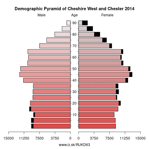
| number of inhabitants | 2019 | 339 824 |
| population density | 2018 | 369.6 |
| old-age dependency ratio | 2019 | 35 |
Other: Cheshire, Cheshire East, Cheshire West and Chester, Warrington
Neighbours: Wirral, North Wales, Cheshire East, Shropshire, Warrington, East Merseyside
Suggested citation: Michal Páleník: Europe and its regions in numbers - Cheshire West and Chester – UKD63, IZ Bratislava, retrieved from: https://www.iz.sk/PUKD63, ISBN: 978-80-970204-9-1, DOI:10.5281/zenodo.10200164
https://www.iz.sk/en/projects/eu-regions/UKD63
 Share
Share Facebook
 Twitter
 News
News