Shropshire – UKG22
EU regions: United Kingdom > West Midlands > Shropshire and Staffordshire > Shropshire
| Indicator | Period | Value |
|---|
Shropshire slovensky: UKG22
Demographics
| Indicator | Period | Value |
|---|---|---|
| Demographics | ||
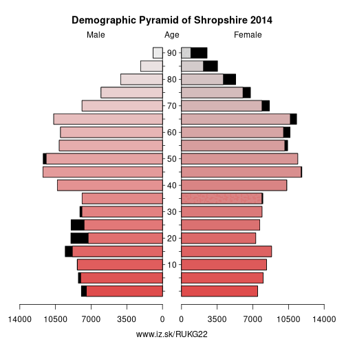
| number of inhabitants | 2019 | 319 189 |
| population density | 2018 | 99.5 |
| old-age dependency ratio | 2019 | 40.9 |
From Wikipedia :
Shropshire (; alternatively Salop; abbreviated, in print only, Shrops; demonym Salopian sə-LOH-pee-ən, Welsh: Swydd Amwythig) is a county in England, bordering Wales to the west, Cheshire to the north, Staffordshire to the east, and Worcestershire and Herefordshire to the south. Shropshire Council was created in 2009, a unitary authority taking over from the previous county council and five district councils. The borough of Telford and Wrekin has been a separate unitary authority since 1998 but continues to be included in the ceremonial county.The county's population and economy is centred on five towns: the county town of Shrewsbury, which is culturally and historically important and close to the centre of the county; Telford, a new town in the east which was constructed around a number of older towns, most notably Wellington, Dawley and Madeley, which is today the most populous; and Oswestry in the northwest, Bridgnorth just to the south of Telford, and Ludlow in the south. The county has many market towns, including Whitchurch in the north, Newport northeast of Telford and Market Drayton in the northeast of the county.
The Ironbridge Gorge area is a UNESCO World Heritage Site, covering Ironbridge, Coalbrookdale and a part of Madeley. There are other historic industrial sites in the county, such as at Shrewsbury, Broseley, Snailbeach and Highley, as well as the Shropshire Union Canal.
The Shropshire Hills Area of Outstanding Natural Beauty covers about a quarter of the county, mainly in the south. Shropshire is one of England's most rural and sparsely populated counties, with a population density of 136/km2 (350/sq mi). The Wrekin is one of the most famous natural landmarks in the county, though the highest hills are the Clee Hills, Stiperstones and the Long Mynd. Wenlock Edge is another significant geographical and geological landmark.
Other: Shropshire and Staffordshire, Telford and Wrekin, Shropshire, City of Stoke-on-Trent, Staffordshire
Neighbours: Telford and Wrekin, North Wales, Staffordshire, Cheshire West and Chester, Cheshire East, Powys, Worcestershire, Herefordshire
Suggested citation: Michal Páleník: Europe and its regions in numbers - Shropshire – UKG22, IZ Bratislava, retrieved from: https://www.iz.sk/PUKG22, ISBN: 978-80-970204-9-1, DOI:10.5281/zenodo.10200164
 Share
Share Facebook
 Twitter
 News
News