Cumbria – UKD1
EU regions: United Kingdom > North West England > Cumbria
| Indicator | Period | Value |
|---|---|---|
| Life long learning | ||
| life long learning participation | 2019 | 14.2 |
| Part time jobs and flexible employment | ||
| percentage of part time workers | 2019 | 29.54 |
| percentage of part time workers, men | 2019 | 11.23 |
| percentage of part time workers, women | 2019 | 50.34 |
| Gender differences | ||
| gender gap in employment rate | 2019 | 92.81 |
| gender gap in unemployment rate | 2015 | 90.91 |
| Graduates and young people | ||
| unemployment rate of youth with elementary education | 2010 | 40.8 |
| NEET | 2018 | 7.4 |
| Employment | ||
| employment rate | 2019 | 80.5 |
Cumbria slovensky: UKD1
Subregions: West Cumbria, East Cumbria
Unemployment
| Indicator | Period | Value |
|---|---|---|
| Unemployment | ||
| unemployment rate | 2019 | 2.1 |
| youth unemployment rate | 2014 | 11 |
| Long term unemployment | ||
| long term unemployment | 2015 | 2 |
| share of long term unemployed | 2015 | 46.7 |
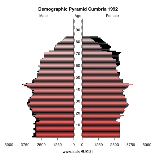
Demographics
| Indicator | Period | Value |
|---|---|---|
| Demographics | ||
| number of inhabitants | 2019 | 498 083 |
| population density | 2018 | 73.6 |
| old-age dependency ratio | 2019 | 40.3 |
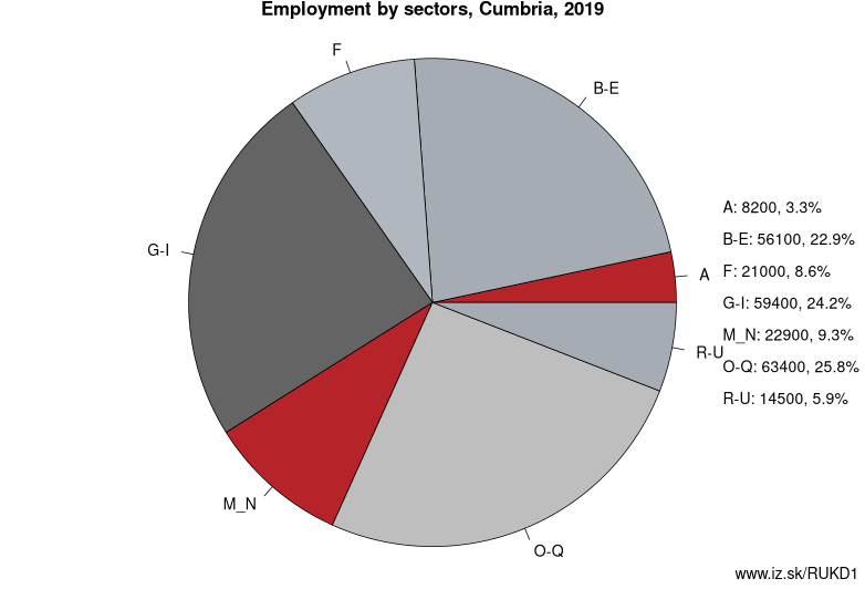
Employment by sectors, Cumbria
| NACE r2 | % | NACE r2 | % | ||
|---|---|---|---|---|---|
| A | 8.2 | 3% | B-E | 56.1 | 22% |
| F | 21 | 8% | G-I | 59.4 | 23% |
| M_N | 22.9 | 9% | O-Q | 63.4 | 25% |
| R-U | 14.5 | 6% | TOTAL | 253.3 | 100% |
Data for the period year 2019. Source of the data is Eurostat, table [lfst_r_lfe2en2].
From Wikipedia :
Cumbria ( KUM-bree-ə) is a ceremonial and non-metropolitan county in North West England. The county and Cumbria County Council, its local government, came into existence in 1974 after the passage of the Local Government Act 1972. Cumbria's county town is Carlisle, in the north of the county, and the only other major urban area is Barrow-in-Furness on the southwestern tip of the county.The county of Cumbria consists of six districts (Allerdale, Barrow-in-Furness, Carlisle, Copeland, Eden, and South Lakeland) and in 2008 had a population of just under 500,000 people. Cumbria is one of the most sparsely populated counties in the United Kingdom, with 73.4 people per km2 (190/sq mi).
Cumbria is the third largest county in England by area, and is bounded to the north by the Scottish council areas of Dumfries and Galloway and Scottish Borders, to the west by the Irish Sea, to the south by Lancashire, to the southeast by North Yorkshire, and to the east by County Durham and Northumberland.
Cumbria is predominantly rural and contains the Lake District National Park, a UNESCO World Heritage Site considered one of England's finest areas of natural beauty, serving as inspiration for artists, writers, and musicians. A large area of the southeast of the county is within the Yorkshire Dales National Park while the east of the county fringes the North Pennines AONB. Much of Cumbria is mountainous, and it contains every peak in England over 3,000 feet (910 m) above sea level, with Scafell Pike at 3,209 feet (978 m) being the highest point of England. An upland, coastal, and rural area, Cumbria's history is characterised by invasions, migration, and settlement, as well as battles and skirmishes between the English and the Scots. Notable historic sites in Cumbria include Carlisle Castle, Furness Abbey, Hardknott Roman Fort, Brough Castle and Hadrian's Wall (also a World Heritage Site).
Other: North West England, Merseyside, Cumbria, Greater Manchester, Lancashire, Cheshire
Neighbours: Northumberland and Tyne and Wear, Tees Valley, Southern Scotland, Lancashire, North Yorkshire
Subregions: West Cumbria, East Cumbria
Suggested citation: Michal Páleník: Europe and its regions in numbers - Cumbria – UKD1, IZ Bratislava, retrieved from: https://www.iz.sk/PUKD1, ISBN: 978-80-970204-9-1, DOI:10.5281/zenodo.10200164
 Share
Share Facebook
 Twitter
 News
News