London Borough of Wandsworth – UKI34
EU regions: United Kingdom > Greater London > Inner London – West > London Borough of Wandsworth
| Indicator | Period | Value |
|---|
London Borough of Wandsworth slovensky: UKI34
Demographics
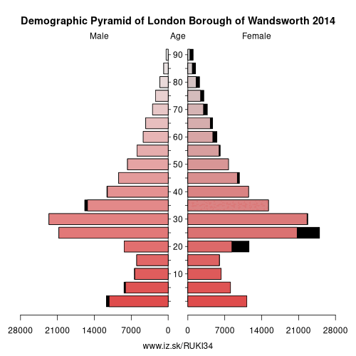
| Indicator | Period | Value |
|---|---|---|
| Demographics | ||
| number of inhabitants | 2019 | 327 451 |
| population density | 2018 | 9594.9 |
| old-age dependency ratio | 2019 | 12.9 |
Other: Inner London – West, City of Westminster, Kensington & Chelsea and Hammersmith & Fulham, Camden and City of London, London Borough of Wandsworth
Neighbours: Hounslow and Richmond upon Thames, Merton, Kingston upon Thames and Sutton, London Borough of Lambeth
Suggested citation: Michal Páleník: Europe and its regions in numbers - London Borough of Wandsworth – UKI34, IZ Bratislava, retrieved from: https://www.iz.sk/PUKI34, ISBN: 978-80-970204-9-1, DOI:10.5281/zenodo.10200164
https://www.iz.sk/en/projects/eu-regions/UKI34
 Share
Share Facebook
 Twitter
 News
News