Hackney and Newham – UKI41
EU regions: United Kingdom > Greater London > Inner London – East > Hackney and Newham
| Indicator | Period | Value |
|---|
Hackney and Newham slovensky: UKI41
Demographics
| Indicator | Period | Value |
|---|---|---|
| Demographics | ||
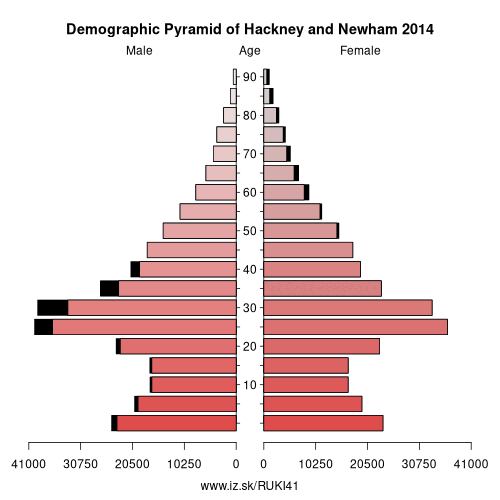
| number of inhabitants | 2019 | 638 859 |
| population density | 2018 | 11 545 |
| old-age dependency ratio | 2019 | 10.4 |
Other: Inner London – East, Hackney and Newham, London Borough of Tower Hamlets, Haringey and Islington, Lewisham and Southwark, London Borough of Lambeth
Neighbours: Redbridge and Waltham Forest, Haringey and Islington, Camden and City of London, Barking & Dagenham and Havering, London Borough of Tower Hamlets
Suggested citation: Michal Páleník: Europe and its regions in numbers - Hackney and Newham – UKI41, IZ Bratislava, retrieved from: https://www.iz.sk/PUKI41, ISBN: 978-80-970204-9-1, DOI:10.5281/zenodo.10200164
https://www.iz.sk/en/projects/eu-regions/UKI41
 Share
Share Facebook
 Twitter
 News
News