Antrim and Newtownabbey – UKN13
EU regions: United Kingdom > Northern Ireland > Antrim and Newtownabbey
| Indicator | Period | Value |
|---|
Antrim and Newtownabbey slovensky: UKN13
Demographics
| Indicator | Period | Value |
|---|---|---|
| Demographics | ||
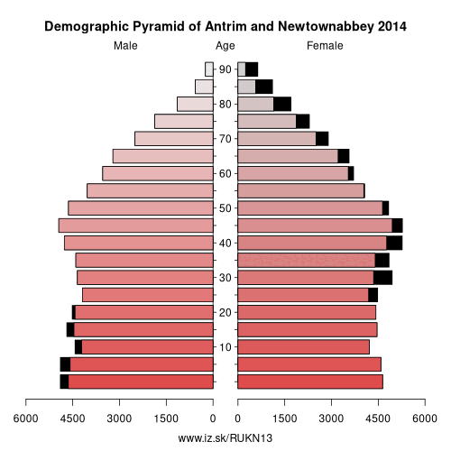
| number of inhabitants | 2019 | 142 565 |
| population density | 2018 | 248.7 |
| old-age dependency ratio | 2019 | 26.3 |
Other: Derry City and Strabane, Causeway Coast and Glens, Mid Ulster, Lisburn and Castlereagh, Mid and East Antrim, Fermanagh and Omagh, Antrim and Newtownabbey
Neighbours: Armagh City, Banbridge and Craigavon, Lisburn and Castlereagh, Mid Ulster, Mid and East Antrim, Belfast
Suggested citation: Michal Páleník: Europe and its regions in numbers - Antrim and Newtownabbey – UKN13, IZ Bratislava, retrieved from: https://www.iz.sk/PUKN13, ISBN: 978-80-970204-9-1, DOI:10.5281/zenodo.10200164
https://www.iz.sk/en/projects/eu-regions/UKN13
 Share
Share Facebook
 Twitter
 News
News