Άνδρος, Θήρα, Κέα, Μήλος, Μύκονος, Νάξος, Πάρος, Σύρος, Τήνος – EL422
EU regions: Greece > Aegean Islands and Crete > South Aegean Region > Άνδρος, Θήρα, Κέα, Μήλος, Μύκονος, Νάξος, Πάρος, Σύρος, Τήνος
| Indicator | Period | Value |
|---|---|---|
| Gross domestic product | ||
| GDP per capita in PPS of EU average | 2023 | 86 |
Άνδρος, Θήρα, Κέα, Μήλος, Μύκονος, Νάξος, Πάρος, Σύρος, Τήνος slovensky: EL422
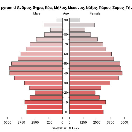
Demographics
| Indicator | Period | Value |
|---|---|---|
| Demographics | ||
| number of inhabitants | 2025 | 115 949 |
| population density | 2024 | 45.6 |
| old-age dependency ratio | 2025 | 36.9 |
Other: South Aegean Region, Κάλυμνος, Κάρπαθος, Κως, Ρόδος, Άνδρος, Θήρα, Κέα, Μήλος, Μύκονος, Νάξος, Πάρος, Σύρος, Τήνος
Suggested citation: Michal Páleník: Europe and its regions in numbers - Άνδρος, Θήρα, Κέα, Μήλος, Μύκονος, Νάξος, Πάρος, Σύρος, Τήνος – EL422, IZ Bratislava, retrieved from: https://www.iz.sk/PEL422, ISBN: 978-80-970204-9-1, DOI:10.5281/zenodo.10200164
https://www.iz.sk/en/projects/eu-regions/EL422
 Share
Share Facebook
 Twitter
 News
News