Budapest – HU110
EU regions: Hungary > Central Hungary > Budapest > Budapest
| Indicator | Period | Value |
|---|---|---|
| Gross domestic product | ||
| GDP per capita in PPS of EU average | 2024 | 168 |
Budapest slovensky: HU110
Unemployment
| Indicator | Period | Value |
|---|---|---|
| Unemployment according to labour offices | ||
| number of registered unemployed | April 2026 | 22 549 |
| number of unemployed women | April 2026 | 12 340 |
| number of vacancies | April 2026 | 21 277 |
Comparison of unemployment according to ILO methodology and registered unemployment yields some differences.
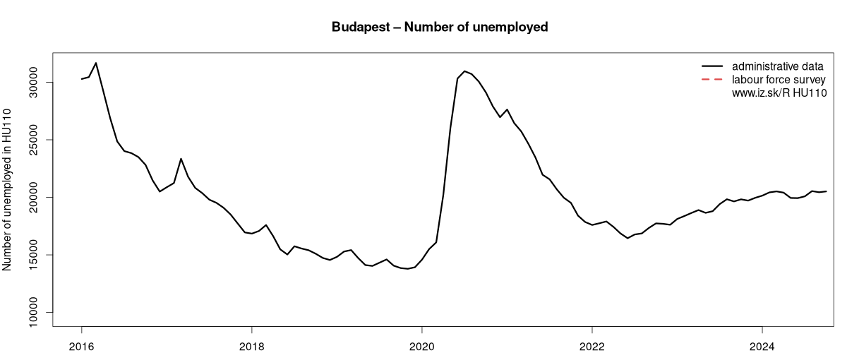
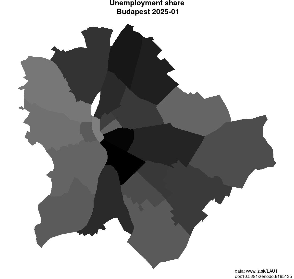
Data on unemployment in counties of Budapest are available at Local Administrative Units data of Visegrad countries.
Demographics
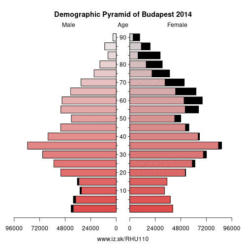
| Indicator | Period | Value |
|---|---|---|
| Demographics | ||
| number of inhabitants | 2025 | 1 685 209 |
| population density | 2024 | 3305.3 |
| old-age dependency ratio | 2025 | 31.1 |
From Wikipedia :
Budapest (, Hungarian pronunciation: [ˈbudɒpɛʃt]) is the capital and the most populous city of Hungary, and the ninth-largest city in the European Union by population within city limits. The city has an estimated population of 1,752,286 over a land area of about 525 square kilometres (203 square miles). Budapest is both a city and county, and forms the centre of the Budapest metropolitan area, which has an area of 7,626 square kilometres (2,944 square miles) and a population of 3,303,786, comprising 33 % of the population of Hungary.The history of Budapest began when an early Celtic settlement transformed into the Roman town of Aquincum, the capital of Lower Pannonia. The Hungarians arrived in the territory in the late 9th century, but the area was pillaged by the Mongols in 1241–42. Re-established Buda became one of the centres of Renaissance humanist culture by the 15th century.
The Battle of Mohács, in 1526, was followed by nearly 150 years of Ottoman rule. After the reconquest of Buda in 1686, the region entered a new age of prosperity, with Pest-Buda becoming a global city after the unification of Buda, Óbuda, and Pest on 17 November 1873, with the name 'Budapest' given to the new capital. Budapest also became the co-capital of the Austro-Hungarian Empire, a great power that dissolved in 1918, following World War I. The city was the focal point of the Hungarian Revolution of 1848, the Battle of Budapest in 1945, and the Hungarian Revolution of 1956.Budapest is a Beta + global city with strengths in commerce, finance, media, art, fashion, research, technology, education, and entertainment. It is Hungary's financial centre and was ranked as the second fastest-developing urban economy in Europe. Budapest is the headquarters of the European Institute of Innovation and Technology, the European Police College and the first foreign office of the China Investment Promotion Agency.
Neighbours: Pest County
Suggested citation: Michal Páleník: Europe and its regions in numbers - Budapest – HU110, IZ Bratislava, retrieved from: https://www.iz.sk/PHU110, ISBN: 978-80-970204-9-1, DOI:10.5281/zenodo.10200164
Local Administrative Units data of Visegrad countries
Statistical data on LAU1 regions of Slovakia, Czechia, Poland, Hungary. This LAU1 panel data dataset on 556 regions contains data on population, age structure of inhabitants, on number and structure of unemployed and is regularly updated.. . .
Similar articles
Regions of the European Union, Regions of the Slovak Republic, Changes in the LAU1 dataset, Vacancies, Unemployment structure in the Visegrad region, Local Administrative Units data of Visegrad countries, Labour market indicators of slovak regions., Counties of Slovakia, Unemployment of Czechia and Slovakia
 Share
Share Facebook
 Twitter
 News
News