London Borough of Enfield – UKI54
EU regions: United Kingdom > Greater London > Outer London – East and North East > London Borough of Enfield
| Indicator | Period | Value |
|---|
London Borough of Enfield slovensky: UKI54
Demographics
| Indicator | Period | Value |
|---|---|---|
| Demographics | ||
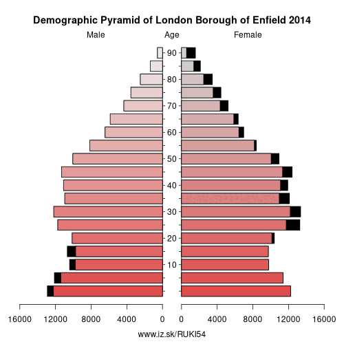
| number of inhabitants | 2019 | 338 201 |
| population density | 2018 | 4162.2 |
| old-age dependency ratio | 2019 | 20 |
Other: Outer London – East and North East, Bexley and Greenwich, Barking & Dagenham and Havering, Redbridge and Waltham Forest, London Borough of Enfield
Neighbours: Hertfordshire, Redbridge and Waltham Forest, Haringey and Islington, West Essex, London Borough of Barnet
Suggested citation: Michal Páleník: Europe and its regions in numbers - London Borough of Enfield – UKI54, IZ Bratislava, retrieved from: https://www.iz.sk/PUKI54, ISBN: 978-80-970204-9-1, DOI:10.5281/zenodo.10200164
https://www.iz.sk/en/projects/eu-regions/UKI54
 Share
Share Facebook
 Twitter
 News
News