Hertfordshire – UKH23
EU regions: United Kingdom > East of England > Bedfordshire and Hertfordshire > Hertfordshire
| Indicator | Period | Value |
|---|
Hertfordshire slovensky: UKH23
Demographics
| Indicator | Period | Value |
|---|---|---|
| Demographics | ||
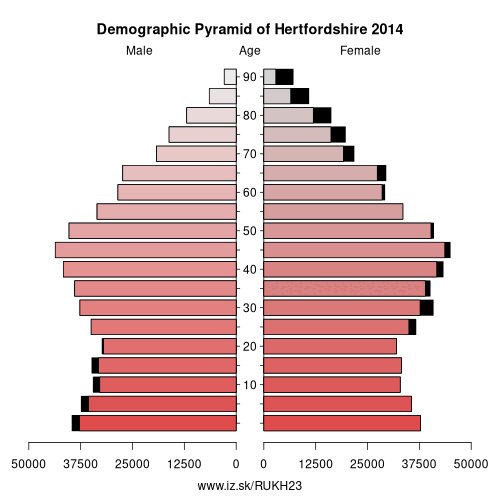
| number of inhabitants | 2019 | 1 194 634 |
| population density | 2018 | 725.2 |
| old-age dependency ratio | 2019 | 26.8 |
From Wikipedia :
Hertfordshire ( (listen); often abbreviated Herts) is one of the home counties in southern England. It is bordered by Bedfordshire and Cambridgeshire to the north, Essex to the east, Greater London to the south, and Buckinghamshire to the west. For government statistical purposes, it is placed in the East of England region.In 2013, the county had a population of 1,140,700 in an area of 634 square miles (1,640 km2). The four towns that have between 50,000 and 100,000 residents are Hemel Hempstead, Stevenage, Watford and St Albans. Hertford, once the main market town for the medieval agricultural county, derives its name from a hart (stag) and a ford, used as the components of the county's coat of arms and flag. Elevations are high for the region in the north and west. These reach over 800 feet (240 m) in the western projection around Tring which is in the Chilterns. The county's borders are approximately the watersheds of the Colne and Lea; both flowing to the south; each accompanied by a canal. Hertfordshire's undeveloped land is mainly agricultural and much is protected by green belt.
Other: Bedfordshire and Hertfordshire, Luton, Hertfordshire, Bedford, Central Bedfordshire
Neighbours: Harrow and Hillingdon, West Essex, Luton, London Borough of Enfield, Cambridgeshire, Buckinghamshire, Central Bedfordshire, London Borough of Barnet
Suggested citation: Michal Páleník: Europe and its regions in numbers - Hertfordshire – UKH23, IZ Bratislava, retrieved from: https://www.iz.sk/PUKH23, ISBN: 978-80-970204-9-1, DOI:10.5281/zenodo.10200164
 Share
Share Facebook
 Twitter
 News
News