London Borough of Barnet – UKI71
EU regions: United Kingdom > Greater London > Outer London – West and North West > London Borough of Barnet
| Indicator | Period | Value |
|---|
London Borough of Barnet slovensky: UKI71
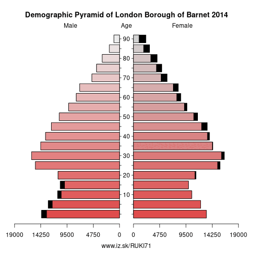
Demographics
| Indicator | Period | Value |
|---|---|---|
| Demographics | ||
| number of inhabitants | 2019 | 395 839 |
| population density | 2018 | 4525.1 |
| old-age dependency ratio | 2019 | 21.9 |
Other: Outer London – West and North West, London Borough of Barnet, London Borough of Brent, London Borough of Ealing, Harrow and Hillingdon, Hounslow and Richmond upon Thames
Neighbours: London Borough of Enfield, Harrow and Hillingdon, Hertfordshire, Haringey and Islington, London Borough of Brent, Camden and City of London
Suggested citation: Michal Páleník: Europe and its regions in numbers - London Borough of Barnet – UKI71, IZ Bratislava, retrieved from: https://www.iz.sk/PUKI71, ISBN: 978-80-970204-9-1, DOI:10.5281/zenodo.10200164
https://www.iz.sk/en/projects/eu-regions/UKI71
 Share
Share Facebook
 Twitter
 News
News