Saarpfalz-Kreis – DEC05
EU regions: Germany > Saarland > Saarland > Saarpfalz-Kreis
| Indicator | Period | Value |
|---|---|---|
| Gross domestic product | ||
| GDP per capita in PPS of EU average | 2023 | 110 |
Saarpfalz-Kreis slovensky: DEC05
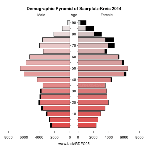
Demographics
| Indicator | Period | Value |
|---|---|---|
| Demographics | ||
| number of inhabitants | 2025 | 144 092 |
| population density | 2024 | 345.2 |
| old-age dependency ratio | 2025 | 44.3 |
From Wikipedia :
Saarpfalz (Saar-Palatinate) is a Kreis (district) in the south-east of the Saarland, Germany. Neighboring districts are (from west clockwise) Saarbrücken, Neunkirchen, Kusel, Kaiserslautern, Südwestpfalz, district-free Zweibrücken, and the French département Moselle.History
After the Treaty of Versailles, the Saar basin was placed under the administration of the League of Nations for 15 years. The Palatinate area, then part of Bavaria, was therefore split in two parts. The part which went into the Saar became commonly known as Saarpfalz, and was administrated by the two Bezirksamt St. Ingbert and Homburg. The Saarpfalz district was created in 1974 when the St. Ingbert and Homburg districts were merged. Since 1997 the district has had a partnership with Henrico County, Virginia.
Other: Saarland, Neunkirchen, St. Wendel, Regionalverband Saarbrücken, Saarlouis, Merzig-Wadern, Saarpfalz-Kreis
Neighbours: Kusel, Neunkirchen, Moselle, Zweibrücken, Südwestpfalz, Kaiserslautern, Regionalverband Saarbrücken
Suggested citation: Michal Páleník: Europe and its regions in numbers - Saarpfalz-Kreis – DEC05, IZ Bratislava, retrieved from: https://www.iz.sk/PDEC05, ISBN: 978-80-970204-9-1, DOI:10.5281/zenodo.10200164
 Share
Share Facebook
 Twitter
 News
News