Agglomeratie Leiden en Bollenstreek – NL337
EU regions: Netherlands > Western Netherlands > South Holland > Agglomeratie Leiden en Bollenstreek
| Indicator | Period | Value |
|---|
Agglomeratie Leiden en Bollenstreek slovensky: NL337
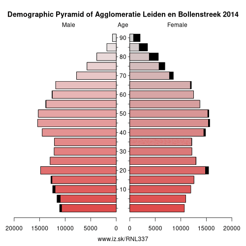
Demographics
| Indicator | Period | Value |
|---|---|---|
| Demographics | ||
| number of inhabitants | 2023 | 440 312 |
| population density | 2022 | 1534.8 |
| old-age dependency ratio | 2023 | 30.8 |
Other: South Holland, Agglomeratie's-Gravenhage, Agglomeratie Leiden en Bollenstreek, Zuidoost-Zuid-Holland, Oost-Zuid-Holland, Groot-Rijnmond, Delft en Westland
Neighbours: Groot-Amsterdam, Oost-Zuid-Holland, Agglomeratie's-Gravenhage, Haarlem
Suggested citation: Michal Páleník: Europe and its regions in numbers - Agglomeratie Leiden en Bollenstreek – NL337, IZ Bratislava, retrieved from: https://www.iz.sk/PNL337, ISBN: 978-80-970204-9-1, DOI:10.5281/zenodo.10200164
https://www.iz.sk/en/projects/eu-regions/NL337
 Share
Share Facebook
 Twitter
 News
News