Aust-Agder – NO041
EU regions: Norway > Norway > Agder og Rogaland > Aust-Agder
| Indicator | Period | Value |
|---|
Aust-Agder slovensky: NO041
Demographics
| Indicator | Period | Value |
|---|---|---|
| Demographics | ||
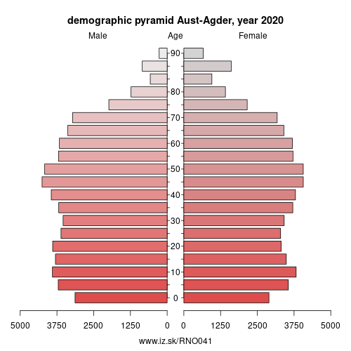
| number of inhabitants | 2020 | 118 273 |
| population density | 2020 | 13.8 |
| old-age dependency ratio | 2020 | 30 |
From Wikipedia : Aust-Agder ([²æʉstˌɑɡdər] (listen), English: East Agder) is one of 18 counties (fylker) in Norway, bordering Telemark, Rogaland, and Vest-Agder counties. In 2002, there were 102,945 inhabitants, which is 2.2 % of the total population in Norway. Its area is 9,212 square kilometres (3,557 sq mi). The administrative center of the county is the town of Arendal.
The county, which is located at the Skagerrak coast, extends from Gjernestangen at Risør to the Kvåsefjorden in Lillesand. The inner parts of the area includes Setesdalsheiene and Austheiene. The majority of the population live near the coast; about 78 % of the county's inhabitants live in the five coastal municipalities of Arendal, Grimstad, Lillesand, Tvedestrand, and Risør. The rest of the county is sparsely populated. Tourism is important, as Arendal and the other coastal towns are popular attractions.
The county includes the larger islands of Tromøya, Hisøya, Justøya, and Sandøya.
Other: Agder og Rogaland, Vest-Agder, Rogaland, Aust-Agder
Neighbours: Rogaland, Vest-Agder, Telemark
Suggested citation: Michal Páleník: Europe and its regions in numbers - Aust-Agder – NO041, IZ Bratislava, retrieved from: https://www.iz.sk/PNO041, ISBN: 978-80-970204-9-1, DOI:10.5281/zenodo.10200164
 Share
Share Facebook
 Twitter
 News
News