West Bačka District – RS121
EU regions: Serbia > Serbia-North > Vojvodina > West Bačka District
| Indicator | Period | Value |
|---|---|---|
| Gross domestic product | ||
| GDP per capita in PPS of EU average | 2023 | 31 |
West Bačka District slovensky: RS121
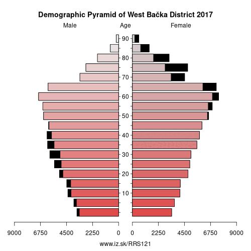
Demographics
| Indicator | Period | Value |
|---|---|---|
| Demographics | ||
| number of inhabitants | 2025 | 150 317 |
| population density | 2019 | 69.8 |
| old-age dependency ratio | 2025 | 40.5 |
Other: Vojvodina, West Bačka District, South Bačka District, North Banat District, Srem District, Central Banat District, North Bačka District, South Banat District
Neighbours: North Bačka District, South Bačka District, Bács-Kiskun County, Osječko-baranjska županija
Suggested citation: Michal Páleník: Europe and its regions in numbers - West Bačka District – RS121, IZ Bratislava, retrieved from: https://www.iz.sk/PRS121, ISBN: 978-80-970204-9-1, DOI:10.5281/zenodo.10200164
https://www.iz.sk/en/projects/eu-regions/RS121
 Share
Share Facebook
 Twitter
 News
News