Derby – UKF11
EU regions: United Kingdom > East Midlands > Derbyshire and Nottinghamshire > Derby
| Indicator | Period | Value |
|---|
Derby slovensky: UKF11
Demographics
| Indicator | Period | Value |
|---|---|---|
| Demographics | ||
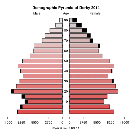
| number of inhabitants | 2019 | 258 746 |
| population density | 2018 | 3313.4 |
| old-age dependency ratio | 2019 | 25.5 |
From Wikipedia :
Derby ( (listen) DAR-bee) is a city and unitary authority area in Derbyshire, England. It lies on the banks of the River Derwent in the south of Derbyshire, of which it was traditionally the county town. At the 2011 census, the population was 248,700. Derby gained city status in 1977.Derby was settled by Romans – who established the town of Derventio – Saxons and Vikings, who made Derby one of the Five Boroughs of the Danelaw. Initially a market town, Derby grew rapidly in the industrial era. Home to Lombe's Mill, an early British factory, Derby has a claim to be one of the birthplaces of the Industrial Revolution. It contains the southern part of the Derwent Valley Mills World Heritage Site. With the arrival of the railways in the 19th century, Derby became a centre of the British rail industry.
Derby is a centre for advanced transport manufacturing, home to the world's second largest aero-engine manufacturer, Rolls-Royce.
Other: Derbyshire and Nottinghamshire, Derbyshire, Derby, East Derbyshire, Nottingham, North Nottinghamshire, Nottinghamshire
Neighbours: Derbyshire
Suggested citation: Michal Páleník: Europe and its regions in numbers - Derby – UKF11, IZ Bratislava, retrieved from: https://www.iz.sk/PUKF11, ISBN: 978-80-970204-9-1, DOI:10.5281/zenodo.10200164
 Share
Share Facebook
 Twitter
 News
News