Rhein-Erft District – DEA27
EU regions: Germany > North Rhine-Westphalia > Cologne Government Region > Rhein-Erft District

| Indicator | Period | Value |
|---|---|---|
| Gross domestic product | ||
| GDP per capita in PPS of EU average | 2023 | 99 |
Rhein-Erft District slovensky: DEA27
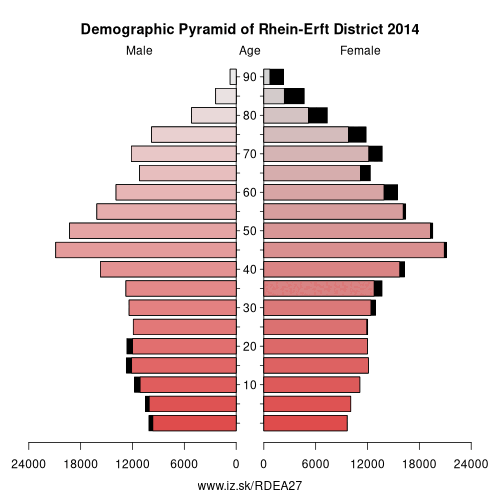
Demographics
| Indicator | Period | Value |
|---|---|---|
| Demographics | ||
| number of inhabitants | 2025 | 477 988 |
| population density | 2024 | 681.7 |
| old-age dependency ratio | 2025 | 35.1 |
From Wikipedia : The Rhein-Erft-Kreis is a district in the west of North Rhine-Westphalia, Germany. Neighboring districts are Neuss, district-free Cologne, Rhein-Sieg, Euskirchen, Düren.
History
The district in its current borders was created in 1975, when the previous districts Bergheim and Cologne were merged. Becoming effective on November 1, 2003 the district was renamed from Erftkreis to Rhein-Erft-Kreis.
Geography
The main river in the district is the Erft, which also gave it the name. The Erft flows through the foothills of the Eifel, on the left side of the Rhine river. The lake Bleibtreusee is located within the district.
Towns
Coat of arms
The coat of arms shows the lion of Jülich in the left half, as most of the area belonged to the duchy of Jülich. The right side shows the Cologne cross, which stands for the former Cologne district. On top the Erft river is depicted; the Prussian Rhine Province had the same symbol in its coat of arms.
Other: Cologne Government Region, Rhein-Erft District, Euskirchen, Oberbergischer Kreis, Düren district, Cologne, Rhein-Sieg District, Bonn, Leverkusen, Rhein-Berg District, Heinsberg, Aachen cities region
Neighbours: Cologne, Rhein-Sieg District, Euskirchen, Rhein-Kreis Neuss, Düren district
Suggested citation: Michal Páleník: Europe and its regions in numbers - Rhein-Erft District – DEA27, IZ Bratislava, retrieved from: https://www.iz.sk/PDEA27, ISBN: 978-80-970204-9-1, DOI:10.5281/zenodo.10200164
 Share
Share Facebook
 Twitter
 News
News