Rhein-Sieg District – DEA2C
EU regions: Germany > North Rhine-Westphalia > Cologne Government Region > Rhein-Sieg District
| Indicator | Period | Value |
|---|---|---|
| Gross domestic product | ||
| GDP per capita in PPS of EU average | 2023 | 79 |
Rhein-Sieg District slovensky: DEA2C
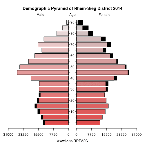
Demographics
| Indicator | Period | Value |
|---|---|---|
| Demographics | ||
| number of inhabitants | 2025 | 605 441 |
| population density | 2024 | 529.2 |
| old-age dependency ratio | 2025 | 37 |
From Wikipedia : The Rhein-Sieg-Kreis is a Kreis (district) in the south of North Rhine-Westphalia, Germany. Neighboring districts are Rheinisch-Bergischer Kreis, Oberbergischer Kreis, Altenkirchen, Neuwied, Ahrweiler, Euskirchen, Rhein-Erft-Kreis, the urban district of Cologne. The federal city of Bonn is nearly completely surrounded by the district.
History
The district as known today was created in 1969, during the reorganization of the districts in North Rhine-Westphalia, by merging Sieg District with the District of Bonn (from which Bonn itself was separated in 1887 to become an urban district). Sieg District was created in 1825.
Geography
Geographically Rhein-Sieg District covers the valley of the river Sieg and also, since the merger with the District of Bonn, that of the Rhine around Bonn, as well an area in the most easterly part of the Eifel.
Other: Cologne Government Region, Euskirchen, Oberbergischer Kreis, Rhein-Sieg District, Düren district, Cologne, Rhein-Erft District, Bonn, Leverkusen, Rhein-Berg District, Heinsberg, Aachen cities region
Neighbours: Altenkirchen district, Rhein-Erft District, Bonn, Neuwied, Oberbergischer Kreis, Ahrweiler, Euskirchen, Rhein-Berg District, Cologne
Suggested citation: Michal Páleník: Europe and its regions in numbers - Rhein-Sieg District – DEA2C, IZ Bratislava, retrieved from: https://www.iz.sk/PDEA2C, ISBN: 978-80-970204-9-1, DOI:10.5281/zenodo.10200164
 Share
Share Facebook
 Twitter
 News
News