Ahrweiler – DEB12
EU regions: Germany > Rhineland-Palatinate > Koblenz Government Region > Ahrweiler
| Indicator | Period | Value |
|---|---|---|
| Gross domestic product | ||
| GDP per capita in PPS of EU average | 2023 | 78 |
Ahrweiler slovensky: DEB12
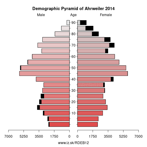
Demographics
| Indicator | Period | Value |
|---|---|---|
| Demographics | ||
| number of inhabitants | 2025 | 129 353 |
| population density | 2024 | 165.3 |
| old-age dependency ratio | 2025 | 42.8 |
Other: Koblenz Government Region, Ahrweiler, Cochem-Zell, Koblenz, Neuwied, Rhein-Hunsrück-Kreis, Westerwaldkreis, Rhein-Lahn-Kreis, Bad Kreuznach, Altenkirchen district, Mayen-Koblenz, Birkenfeld
Neighbours: Mayen-Koblenz, Neuwied, Vulkaneifel, Rhein-Sieg District, Euskirchen
Suggested citation: Michal Páleník: Europe and its regions in numbers - Ahrweiler – DEB12, IZ Bratislava, retrieved from: https://www.iz.sk/PDEB12, ISBN: 978-80-970204-9-1, DOI:10.5281/zenodo.10200164
https://www.iz.sk/en/projects/eu-regions/DEB12
 Share
Share Facebook
 Twitter
 News
News