Hochsauerlandkreis – DEA57
EU regions: Germany > North Rhine-Westphalia > Arnsberg Government Region > Hochsauerlandkreis
| Indicator | Period | Value |
|---|---|---|
| Gross domestic product | ||
| GDP per capita in PPS of EU average | 2023 | 104 |
Hochsauerlandkreis slovensky: DEA57
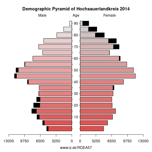
Demographics
| Indicator | Period | Value |
|---|---|---|
| Demographics | ||
| number of inhabitants | 2025 | 260 843 |
| population density | 2024 | 133.5 |
| old-age dependency ratio | 2025 | 38.1 |
From Wikipedia : Hochsauerlandkreis (meaning “High Sauerland District” in German) is a Kreis (district) in the east of North Rhine-Westphalia, Germany. Neighboring districts are Soest, Paderborn, Höxter, Waldeck-Frankenberg, Siegen-Wittgenstein, Olpe, Märkischer Kreis.
The district is named “High Sauerland” because two of the highest mountains of the Sauerland mountainous landscape, Langenberg and Kahler Asten are in its territory. With 2,766 ft / 843 m (Langenberg) and 2,762 ft / 842 m (Kahler Asten) these are also the highest mountains of North Rhine-Westphalia.
History
The district was established in 1975 in the reorganization of the districts in North Rhine-Westphalia by merging the previous districts Arnsberg, Brilon and Meschede.
Geography
Geographically the district covers a big part of the Sauerland mountains, including the highest and third highest elevation – the Langenberg near Olsberg with 2,766 ft / 843 m, and the better known Kahler Asten with 2,762 ft / 842 m near Winterberg. These are also the two highest mountains of North Rhine-Westphalia.
Other: Arnsberg Government Region, Ennepe-Ruhr-Kreis, Soest, Hochsauerlandkreis, Kreis Olpe, Siegen-Wittgenstein, Dortmund, Hamm, Unna, Hagen, Herne, Märkischer Kreis, Bochum
Neighbours: Soest, Kreis Olpe, Märkischer Kreis, Siegen-Wittgenstein, Paderborn, Waldeck-Frankenberg, Höxter
Suggested citation: Michal Páleník: Europe and its regions in numbers - Hochsauerlandkreis – DEA57, IZ Bratislava, retrieved from: https://www.iz.sk/PDEA57, ISBN: 978-80-970204-9-1, DOI:10.5281/zenodo.10200164
 Share
Share Facebook
 Twitter
 News
News