Ennepe-Ruhr-Kreis – DEA56
EU regions: Germany > North Rhine-Westphalia > Arnsberg Government Region > Ennepe-Ruhr-Kreis
| Indicator | Period | Value |
|---|---|---|
| Gross domestic product | ||
| GDP per capita in PPS of EU average | 2023 | 84 |
Ennepe-Ruhr-Kreis slovensky: DEA56
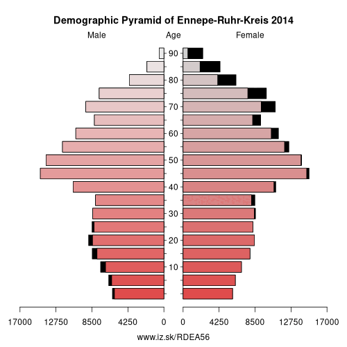
Demographics
| Indicator | Period | Value |
|---|---|---|
| Demographics | ||
| number of inhabitants | 2025 | 314 167 |
| population density | 2024 | 773 |
| old-age dependency ratio | 2025 | 40.6 |
From Wikipedia : The Ennepe-Ruhr-Kreis is a district in the center of North Rhine-Westphalia, Germany. It is part of the southern Ruhr urban area and has ca. 324,000 inhabitants (2012). The district's seat (capital city) is Schwelm; the largest of its nine towns is Witten.
Geography
The name of the district describes its geographical location – it is located in the valleys of the rivers Ruhr and Ennepe. Geologically it is part of the north-eastern Rhenish Massif, a Mittelgebirge landscape; only small parts of Witten belong to the flat Westphalian Lowland.
Municipalities
The district consists of nine municipalities, all entitled „Stadt" (town or city).
Adjacent cities and districts
The Ennepe-Ruhr-Kreis is bounded by (from the north and clockwise) the district-free cities of Bochum, Dortmund and Hagen, the districts of Märkischer Kreis (with Schalksmühle and Halver) and Oberbergischer Kreis (with Radevormwald), the city of Wuppertal, the district of Mettmann (with Velbert) and the city of Essen.
Largest groups of foreigners :
History
The district was created in 1929 by merging the former district of Schwelm with parts of the former districts of Hattingen and Hagen. In 1970 and 1975 it was modified a bit during the reorganization of the districts in North Rhine-Westphalia; most notable was the inclusion of the previously independent city of Witten in 1975.
Other: Arnsberg Government Region, Soest, Ennepe-Ruhr-Kreis, Hochsauerlandkreis, Kreis Olpe, Siegen-Wittgenstein, Dortmund, Hamm, Unna, Hagen, Herne, Märkischer Kreis, Bochum
Neighbours: Hagen, Mettmann, Bochum, Märkischer Kreis, Oberbergischer Kreis, Wuppertal, Essen, Dortmund
Suggested citation: Michal Páleník: Europe and its regions in numbers - Ennepe-Ruhr-Kreis – DEA56, IZ Bratislava, retrieved from: https://www.iz.sk/PDEA56, ISBN: 978-80-970204-9-1, DOI:10.5281/zenodo.10200164
 Share
Share Facebook
 Twitter
 News
News