Breisgau-Hochschwarzwald – DE132
EU regions: Germany > Baden-Württemberg > Freiburg Government Region > Breisgau-Hochschwarzwald
| Indicator | Period | Value |
|---|---|---|
| Gross domestic product | ||
| GDP per capita in PPS of EU average | 2023 | 82 |
Breisgau-Hochschwarzwald slovensky: DE132
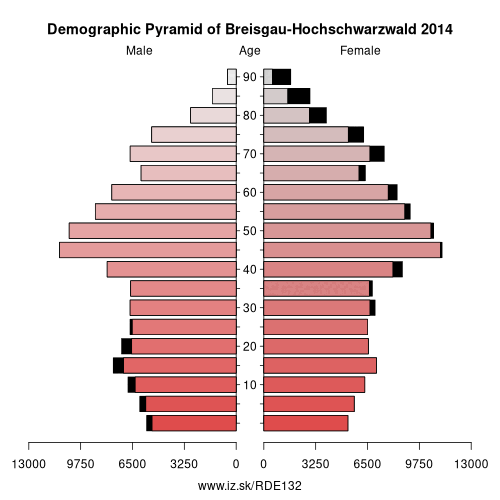
Demographics
| Indicator | Period | Value |
|---|---|---|
| Demographics | ||
| number of inhabitants | 2025 | 272 558 |
| population density | 2024 | 199.3 |
| old-age dependency ratio | 2025 | 38 |
From Wikipedia : Breisgau-Hochschwarzwald (French: Arrondissement de Brisgau-Haute-Forêt-Noire) is a Landkreis (district) in the southwest of Baden-Württemberg, Germany. Fifty towns and municipalities with 133 settlements lie within the district. The district itself belongs to the province of Freiburg with the region of Southern Upper Rhine.
The municipal offices are in the city of Freiburg im Breisgau which is almost entirely surrounded by Breisgau-Hochschwarzwald, but is independent of it. In addition, the council has three satellite offices in Müllheim, Titisee-Neustadt and Breisach am Rhein.
Geography
Location
Breisgau-Hochschwarzwald covers areas which are very different in scenic character: in the Upper Rhine Plain are the Markgräflerland and its foothill zone, which is continued north of the Breisgau with the hills of Kaiserstuhl, the Tuniberg and the Nimberg.
Within the district, the Black Forest covers the side valleys opening onto the Rhine Plain – the Glottertal, the valley of the Dreisam, the Höllental and the Münstertal – the High Black Forest with its highest peak, the Feldberg (1493 m), and extends as far as the plateau of Baar.
In the centre of Breisgau-Hochschwarzwald lies the territory of the city of Freiburg, which is almost entirely surrounded by Breisgau-Hochschwarzwald. Only on its northern side is there a 3-kilometre-long boundary with the municipality of Vörstetten and the district of Emmendingen.
Neighbouring counties
The neighbouring counties are Emmendingen, Schwarzwald-Baar, Waldshut, Lörrach and the French départements of the Haut-Rhin and the Bas-Rhin.
Other: Freiburg Government Region, Emmendingen, Freiburg im Breisgau, Ortenau, Rottweil, Schwarzwald-Baar district, Breisgau-Hochschwarzwald, Tuttlingen, Lörrach, Waldshut, Konstanz
Neighbours: Schwarzwald-Baar district, Lörrach, Freiburg im Breisgau, Haut-Rhin, Waldshut, Emmendingen
Suggested citation: Michal Páleník: Europe and its regions in numbers - Breisgau-Hochschwarzwald – DE132, IZ Bratislava, retrieved from: https://www.iz.sk/PDE132, ISBN: 978-80-970204-9-1, DOI:10.5281/zenodo.10200164
 Share
Share Facebook
 Twitter
 News
News