Schwarzwald-Baar district – DE136
EU regions: Germany > Baden-Württemberg > Freiburg Government Region > Schwarzwald-Baar district
| Indicator | Period | Value |
|---|---|---|
| Gross domestic product | ||
| GDP per capita in PPS of EU average | 2023 | 109 |
Schwarzwald-Baar district slovensky: DE136
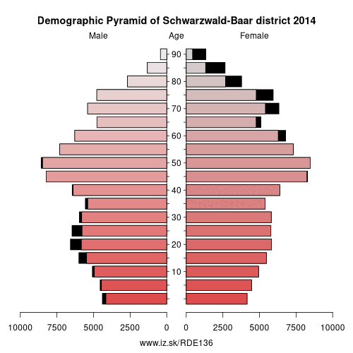
Demographics
| Indicator | Period | Value |
|---|---|---|
| Demographics | ||
| number of inhabitants | 2025 | 214 065 |
| population density | 2024 | 209 |
| old-age dependency ratio | 2025 | 37.7 |
From Wikipedia : Schwarzwald-Baar is a Landkreis (district) in the south of Baden-Württemberg, Germany. Neighboring districts are (from north clockwise) Ortenaukreis, Rottweil, Tuttlingen, Constance, the Swiss canton of Schaffhausen, and the districts Waldshut, Breisgau-Hochschwarzwald and Emmendingen.
History
The district was created in 1973, when the two districts Donaueschingen and Villingen were merged.
Geography
The district got its name from the two predominant landscapes in the district. The Black Forest (Schwarzwald), and the Baar, the foothills between the Black Forest and the Swabian Alb. Both the Danube River and the Neckar River have their origins in the Schwarzwald and Baar district.
Other: Freiburg Government Region, Emmendingen, Freiburg im Breisgau, Ortenau, Rottweil, Schwarzwald-Baar district, Breisgau-Hochschwarzwald, Tuttlingen, Lörrach, Waldshut, Konstanz
Neighbours: Breisgau-Hochschwarzwald, Konstanz, Tuttlingen, Rottweil, Canton of Schaffhausen, Waldshut, Ortenau, Emmendingen
Suggested citation: Michal Páleník: Europe and its regions in numbers - Schwarzwald-Baar district – DE136, IZ Bratislava, retrieved from: https://www.iz.sk/PDE136, ISBN: 978-80-970204-9-1, DOI:10.5281/zenodo.10200164
 Share
Share Facebook
 Twitter
 News
News