Rottweil – DE135
EU regions: Germany > Baden-Württemberg > Freiburg Government Region > Rottweil
| Indicator | Period | Value |
|---|---|---|
| Gross domestic product | ||
| GDP per capita in PPS of EU average | 2023 | 121 |
Rottweil slovensky: DE135
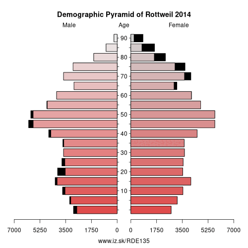
Demographics
| Indicator | Period | Value |
|---|---|---|
| Demographics | ||
| number of inhabitants | 2025 | 140 237 |
| population density | 2024 | 182.4 |
| old-age dependency ratio | 2025 | 35.9 |
Other: Freiburg Government Region, Emmendingen, Freiburg im Breisgau, Ortenau, Rottweil, Schwarzwald-Baar district, Breisgau-Hochschwarzwald, Tuttlingen, Lörrach, Waldshut, Konstanz
Neighbours: Zollernalbkreis, Ortenau, Tuttlingen, Freudenstadt, Schwarzwald-Baar district
Suggested citation: Michal Páleník: Europe and its regions in numbers - Rottweil – DE135, IZ Bratislava, retrieved from: https://www.iz.sk/PDE135, ISBN: 978-80-970204-9-1, DOI:10.5281/zenodo.10200164
https://www.iz.sk/en/projects/eu-regions/DE135
 Share
Share Facebook
 Twitter
 News
News