Erlangen – DE252
EU regions: Germany > Bavaria > Middle Franconia > Erlangen
| Indicator | Period | Value |
|---|---|---|
| Gross domestic product | ||
| GDP per capita in PPS of EU average | 2023 | 276 |
Erlangen slovensky: DE252
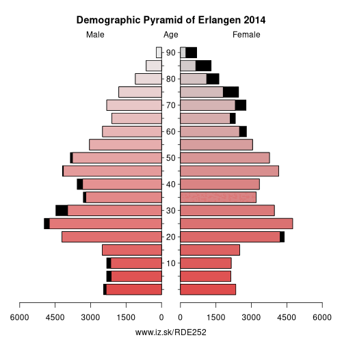
Demographics
| Indicator | Period | Value |
|---|---|---|
| Demographics | ||
| number of inhabitants | 2025 | 115 928 |
| population density | 2024 | 1521.3 |
| old-age dependency ratio | 2025 | 27.3 |
From Wikipedia : Erlangen (German pronunciation: [ˌɛɐ̯ˈlaŋən] (listen); East Franconian: Erlang) is a Middle Franconian city in Bavaria, Germany. It is the seat of the administrative district Erlangen-Höchstadt (former administrative district Erlangen) and with 113,752 inhabitants (as of 31 December 2018) it is the smallest of the eight major cities in Bavaria. The number of inhabitants exceeded the threshold of 100,000 in 1974, making Erlangen a major city.
Together with Nuremberg, Fürth and Schwabach, Erlangen forms one of the three metropolises in Bavaria. With the surrounding area, these cities form the European Metropolitan Region of Nuremberg, one of 11 metropolitan areas in Germany. The cities of Nuremberg, Fürth and Erlangen also form a triangle on a map, which represents the heartland of the Nuremberg conurbation.
An element of the city that goes back a long way in history, but is still noticeable, is the settlement of Huguenots after the withdrawal of the Edict of Nantes in 1685. Today, many aspects of daily life in the city are dominated by the Friedrich Alexander University Erlangen-Nuremberg and the Siemens technology group.
Geography
Erlangen is located on the edge of the Middle Franconian Basin and at the floodplain of the Regnitz river. The river divides the city into two halfs of approximately equal sizes.
Other: Middle Franconia, Erlangen, Fürth, Nürnberger Land, Roth, Nuremberg, Fürth, Erlangen-Höchstadt, Schwabach, Ansbach, Landkreis Neustadt an der Aisch-Bad Windsheim, Ansbach, Weißenburg-Gunzenhausen
Neighbours: Fürth, Erlangen-Höchstadt, Nuremberg, Fürth
Suggested citation: Michal Páleník: Europe and its regions in numbers - Erlangen – DE252, IZ Bratislava, retrieved from: https://www.iz.sk/PDE252, ISBN: 978-80-970204-9-1, DOI:10.5281/zenodo.10200164
 Share
Share Facebook
 Twitter
 News
News