Fürth – DE258
EU regions: Germany > Bavaria > Middle Franconia > Fürth
| Indicator | Period | Value |
|---|---|---|
| Gross domestic product | ||
| GDP per capita in PPS of EU average | 2023 | 64 |
Fürth slovensky: DE258
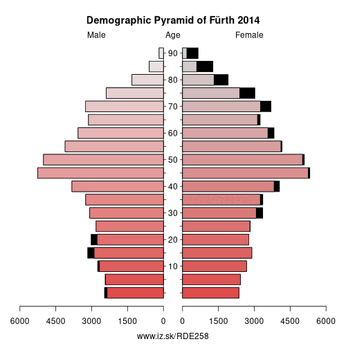
Demographics
| Indicator | Period | Value |
|---|---|---|
| Demographics | ||
| number of inhabitants | 2025 | 117 719 |
| population density | 2024 | 383.3 |
| old-age dependency ratio | 2025 | 39.5 |
Other: Middle Franconia, Erlangen, Fürth, Nürnberger Land, Roth, Nuremberg, Fürth, Erlangen-Höchstadt, Schwabach, Ansbach, Landkreis Neustadt an der Aisch-Bad Windsheim, Ansbach, Weißenburg-Gunzenhausen
Neighbours: Fürth, Erlangen-Höchstadt, Nuremberg, Landkreis Neustadt an der Aisch-Bad Windsheim, Ansbach, Erlangen, Roth
Suggested citation: Michal Páleník: Europe and its regions in numbers - Fürth – DE258, IZ Bratislava, retrieved from: https://www.iz.sk/PDE258, ISBN: 978-80-970204-9-1, DOI:10.5281/zenodo.10200164
https://www.iz.sk/en/projects/eu-regions/DE258
 Share
Share Facebook
 Twitter
 News
News