Weißenburg-Gunzenhausen – DE25C
EU regions: Germany > Bavaria > Middle Franconia > Weißenburg-Gunzenhausen
| Indicator | Period | Value |
|---|---|---|
| Gross domestic product | ||
| GDP per capita in PPS of EU average | 2023 | 92 |
Weißenburg-Gunzenhausen slovensky: DE25C
Demographics
| Indicator | Period | Value |
|---|---|---|
| Demographics | ||
| number of inhabitants | 2025 | 94 695 |
| population density | 2024 | 99 |
| old-age dependency ratio | 2025 | 38 |
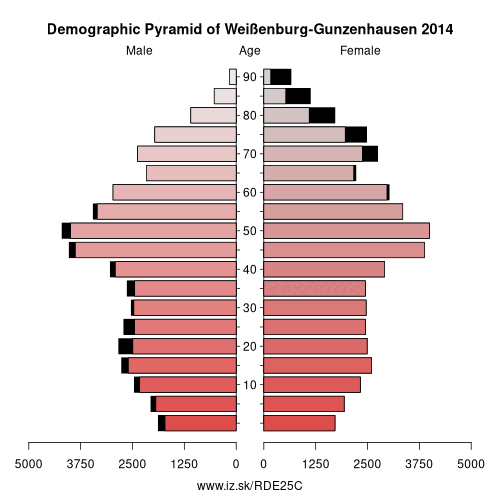
From Wikipedia : Weißenburg-Gunzenhausen is a Landkreis (district) in the west of Bavaria, Germany with a population of 95,000. Neighbouring districts are (from the north clockwise) Ansbach, Roth, Eichstätt and Donau-Ries. It is located in the south of Middle Franconia, 50 kilometres south of Nuremberg. Largest city and the administrative center is Weißenburg in Bayern.
Geography
The district is located on the Hahnenkamm and on the Franconian Alb in the North of the Altmühltal. In the north there are several lakes of the Franconian Lake District. The highest point of the district is the Dürrenberg. The Altmühl flows through the district. From here comes the Solnhofen limestone. Among its nature reserves are the Brombachmoor.
Other: Middle Franconia, Erlangen, Fürth, Nürnberger Land, Roth, Nuremberg, Fürth, Erlangen-Höchstadt, Schwabach, Ansbach, Landkreis Neustadt an der Aisch-Bad Windsheim, Ansbach, Weißenburg-Gunzenhausen
Neighbours: Donau-Ries, Ansbach, Eichstätt district, Roth
Suggested citation: Michal Páleník: Europe and its regions in numbers - Weißenburg-Gunzenhausen – DE25C, IZ Bratislava, retrieved from: https://www.iz.sk/PDE25C, ISBN: 978-80-970204-9-1, DOI:10.5281/zenodo.10200164
 Share
Share Facebook
 Twitter
 News
News