Fürth – DE253
EU regions: Germany > Bavaria > Middle Franconia > Fürth
| Indicator | Period | Value |
|---|---|---|
| Gross domestic product | ||
| GDP per capita in PPS of EU average | 2023 | 110 |
Fürth slovensky: DE253
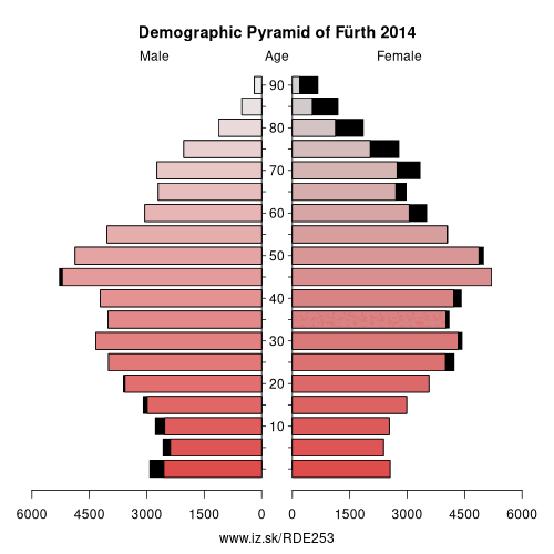
Demographics
| Indicator | Period | Value |
|---|---|---|
| Demographics | ||
| number of inhabitants | 2025 | 132 036 |
| population density | 2024 | 2093.2 |
| old-age dependency ratio | 2025 | 29.5 |
From Wikipedia : Fürth (German: [fʏʁt] (listen); East Franconian: Färdd; Yiddish: פיורדא, romanized: Fiurda) is a city in northern Bavaria, Germany, in the administrative division (Regierungsbezirk) of Middle Franconia. It is now contiguous with the larger city of Nuremberg, the centres of the two cities being only 7 km apart.
Fürth is one of 23 "major centres" in Bavaria. Fürth, Nuremberg, Erlangen and some smaller towns form the „Middle Franconian Conurbation“, which is one of the 11 German metropolitan regions.
Fürth celebrated its thousandth anniversary in 2007, its first mention being on 1 November 1007.
Geography
The historic centre of the town is to the east and south of the rivers Rednitz and Pegnitz, which join to form the Regnitz to the northwest of the Old Town. To the west of the town, on the far side of the Main-Danube Canal, is the Fürth municipal forest (Fürther Stadtwald). To the east of Fürth, at roughly the same latitude, lies Nuremberg, and to the north is the fertile market-gardening area known as the Knoblauchsland (garlic country), some of which is within the borders of the urban district of Fürth. To the south of the town is an area consisting of wide roads, the canal, and meadows.
Neighbouring municipalities
The following towns and municipalities share borders with Fürth; they are listed in clockwise order, starting in the north:
Erlangen and Nuremberg, which are independent urban districts; Stein, Oberasbach, Zirndorf, Cadolzburg, Seukendorf, Veitsbronn, and Obermichelbach, which are municipalities within the rural district (Landkreis) of Fürth.
Other: Middle Franconia, Erlangen, Fürth, Nürnberger Land, Roth, Nuremberg, Fürth, Erlangen-Höchstadt, Schwabach, Ansbach, Landkreis Neustadt an der Aisch-Bad Windsheim, Ansbach, Weißenburg-Gunzenhausen
Neighbours: Fürth, Erlangen, Nuremberg
Suggested citation: Michal Páleník: Europe and its regions in numbers - Fürth – DE253, IZ Bratislava, retrieved from: https://www.iz.sk/PDE253, ISBN: 978-80-970204-9-1, DOI:10.5281/zenodo.10200164
 Share
Share Facebook
 Twitter
 News
News