Hersfeld-Rotenburg – DE733
EU regions: Germany > Hesse > Kassel Government Region > Hersfeld-Rotenburg
| Indicator | Period | Value |
|---|---|---|
| Gross domestic product | ||
| GDP per capita in PPS of EU average | 2023 | 103 |
Hersfeld-Rotenburg slovensky: DE733
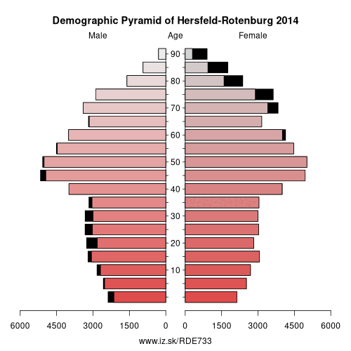
Demographics
| Indicator | Period | Value |
|---|---|---|
| Demographics | ||
| number of inhabitants | 2025 | 117 414 |
| population density | 2024 | 107.3 |
| old-age dependency ratio | 2025 | 42.5 |
From Wikipedia : Hersfeld-Rotenburg is a Kreis (district) in the east of Hesse, Germany. Neighboring districts are Werra-Meißner, Wartburgkreis, Fulda, Vogelsbergkreis, Schwalm-Eder.
History
In 1821 districts were created in Hesse, including the districts Hersfeld and Rotenburg, which stayed nearly unchanged (except a short period after the revolution of 1848 when they were dissolved) through the annexion of Hesse-Kassel (or Hesse-Cassel) by Prussia and the creation of the Hesse state. In 1972 both districts were merged into one.
Geography
The district contains the hilly landscape of Waldhessen, the mountains are of the Knüllgebirge, Stölzinger Gebirge, Richelsdorfer Gebirge and the Kuppenrhön, part of the Rhön mountains.
Other: Kassel Government Region, Waldeck-Frankenberg, Schwalm-Eder-Kreis, Hersfeld-Rotenburg, Landkreis Kassel, Fulda, Kassel, Werra-Meißner-Kreis
Neighbours: Schwalm-Eder-Kreis, Werra-Meißner-Kreis, Fulda, Wartburgkreis, Vogelsbergkreis
Suggested citation: Michal Páleník: Europe and its regions in numbers - Hersfeld-Rotenburg – DE733, IZ Bratislava, retrieved from: https://www.iz.sk/PDE733, ISBN: 978-80-970204-9-1, DOI:10.5281/zenodo.10200164
 Share
Share Facebook
 Twitter
 News
News